Norfolk Minerals and Waste Local Plan 2023-2038 (web version)
General Policies
6. Development Management Criteria
6.1 Minerals and waste developments can result in a range of potential benefits and operational impacts that need to be considered. The planning policy framework provided by this Plan is considered flexible enough to deal with a number of issues that may arise from different development, as well as take into account the local circumstances of each proposal.
6.2 National guidance is clear that Local Plans do not need to repeat or reformulate existing national or local policy or duplicate the existing pollution control regime.
6.3 The 'National and Local Validation Requirements for Minerals and Waste Planning Applications'adopted by the County Planning Authority provides guidance about the particular information that may be required to validate a planning application before it can be determined. Advice on the information to support an application should be sought on a case-by-case basis, normally through pre-application discussions with the County Planning Authority. For any proposal for minerals or waste management development that comes forward for determination, the impact of the proposal on the environment and amenity, as described below, will be carefully assessed and considered before a decision is made.
6.4 Where the impact of the proposal is unacceptable, and such impacts can't be controlled, then planning permission could be refused. Specific measures can, however, be sometimes undertaken to mitigate any potential adverse impact to either local amenity or the environment. Such measures could include, for example, additional landscaping, sustainable drainage schemes, protection of heritage assets, noise attenuation, the design of lighting (including avoidance of light pollution of the night sky), dust and vibration control, nature conservation, good building and site design and restrictions on working hours and lorry movements. The appropriate mitigation will depend on the characteristics of the proposal, the site and the surrounding area.
6.5 The production of waste is a natural result of economic and social activity by businesses and consumers. Wastes can also be an input to economic activity, either as a material or through energy recovery. The management of that waste has economic implications for productivity, government expenditure, and the environment. The waste industry contributes to the economy of Norfolk as an employer and businesses require effective waste management to offset costs associated with disposing of the waste it produces.
6.6 Minerals are essential to support sustainable economic growth and our quality of life. It is therefore important that there is a sufficient supply of material to provide the infrastructure, buildings, energy and goods that the country needs. The minerals industry contributes to the economy of Norfolk as an employer and providing raw materials for the construction of buildings and roads and for glass manufacture.
6.7 The provision of minerals and the management of waste are therefore important to the economic growth of Norfolk and this needs to be taken into consideration when assessing planning applications for minerals or waste management development.
6.8 The Development Management Criteria Policy MW1 details the issues that will be taken into account when reaching a decision on a particular planning application to ensure that permitted sites represent sustainable development.
Policy MW1: Development Management Criteria
Mineral development and waste management development will be acceptable where the proposals demonstrate that the development would not have an unacceptable impact (including cumulative impact in combination with other existing or permitted development) on:
- Local amenity and health (including noise levels, odour, air quality, dust, litter, light pollution and vibration);
- The quality and quantity of surface waterbodies and groundwater, for resource purposes and to prevent the deterioration of their existing status, and their associated ecosystems;
- The capacity of existing drainage systems;
- Flood risk from all sources to those working on site or an increase in flood risk elsewhere, as demonstrated by a Flood Risk Assessment (where required by the National Planning Policy Framework) and making an allowance for climate change;
- The best and most versatile agricultural land;
- Aircraft safety due to the risk of bird strike and/or building height and position;
- The safety and capacity of the road and any other transport network;
- The appearance, quality and character of the landscape, countryside and visual environment, including intrinsically dark landscapes, and any local features that contribute to its local distinctiveness;
- Protected landscapes including the Norfolk Coast Area of Outstanding Natural Beauty, the Heritage Coast and the Broads;
- Public Open Space, Local Green Space, the definitive Public Rights of Way network and outdoor recreation facilities;
- Land stability;
- The natural, geological and hydrogeological environment (including internationally, nationally or locally designated sites and irreplaceable habitats);
- The historic environment (as identified through a Heritage and Archaeology Statement), including heritage and archaeological assets and their settings; and
- The character and quality of the area, in which the development is situated, through poor design.
In addition, all mineral and waste management proposals will be subject to the historic environment policy requirements set out in the NPPF, including striking an appropriate balance between harm and public benefit, but, as a first principle, development should avoid harm on the historic environment. Subject to the development proposal meeting the NPPF historic environment policy requirements, the preferred mitigation for developments affecting archaeological assets of less than national importance will be through the preservation of the archaeological remains in situ. Where in situ preservation is not justified, adequate provision must be made for excavation and recording including subsequent analysis, publication and archive deposition before or during development.
Mineral development and waste management development proposals must also conserve and, where opportunities arise, enhance the natural, built and historic environment and surrounding landscapes, including:
- the setting of heritage assets and protected landscapes,
- providing geodiversity gains, providing a minimum measurable 10% biodiversity net gain and contributing to the delivery of the national Nature Recovery Network objectives,
- enhancement of the Public Rights of Way Network,
- creation of recreation opportunities where possible,
- the reduction of flood risk elsewhere through betterment, and
- incorporating good design.
Pollution and Local Amenity Impacts
6.9 "Local amenity impact" is usually understood to mean the effect of the proposed development on the existing visual and aural characteristics of the immediate neighbourhood, including the impact on any residential and non-residential uses in the vicinity. Impacts on amenity can cover a range of potential pollution and disturbance from, for example, light, noise, dust, and odour as well as concerns of the possible effects on human health from the development. When considering planning applications, the County Planning Authority must be satisfied that those potential adverse impacts have all been satisfactorily investigated and addressed.
6.10 Development proposals for mineral extraction or for open air waste management facilities must provide a dust assessment at the planning application stage. The dust assessment should include: the existing baseline conditions, identify potential sources and activities which could cause or give rise to dust, identify site parameters which may increase potential impacts from dust, propose mitigation measures and dust monitoring. The national PPG (Minerals) states that where dust emissions are likely to arise, mineral operators are expected to prepare a dust assessment study and provides guidance on the five stages of a dust assessment study. The national PPG (Air Quality) provides guidance on when an air quality assessment should be carried out and sets out what information could be included in an air quality assessment. Norfolk County Council's adopted 'National and Local Validation Requirements for Minerals and Waste Planning Applications' states that a dust impact assessment is required for all development for mineral extraction and waste management facilities and sets out what information should be included in dust assessment; it also sets out when an Air Quality Impact Assessment is required to be submitted and the information to be included in the assessment.
6.11 Development proposals must provide a noise assessment at the planning application stage. The noise assessment should include: the existing background noise levels, the location of noise-sensitive properties and sensitive environmental sites, estimate likely noise levels from the development, assess the noise impact on the neighbourhood, propose mitigation measures and noise monitoring. The NPPF (paragraph 216, December 2023) states that some noisy short-term activities, which may otherwise be regarded as unacceptable are unavoidable to facilitate minerals extraction. Examples of these noisy activities are soil-stripping, the construction and removal of baffle mounds, soil storage mounds and spoil heaps, construction of new permanent landforms and aspects of site road construction and maintenance. Detail on noise emissions, the impact of noise, noise standards and the control of noise emissions are contained within the national Planning Practice Guidance.
6.12 Development proposals which provide external lighting must submit lighting details / a lighting assessment at the planning application stage. The Norfolk Coast AONB contains three dark sky discovery sites, and The Broads Local Plan contains a dark skies policy. The Institute of Lighting Professionals has produced a Guidance Note for the Reduction of Obtrusive Light. A lighting assessment must contain details of the impact of any proposed lighting on:
- The amenity of neighbouring properties, specifically if light has the potential to extend beyond the boundary of the site;
- Roads/ highway safety;
- The character of the area and the wider landscape, specifically Conservation Areas, Listed Buildings, Designated Areas (SSSI, Broads Authority Executive Area, AONB) or rural areas with little background light; and
- Ecology, specifically European protected species.
The assessment will need to include reasons to justify the lighting proposed, and identification of any mitigation measures required.
6.13 The National Planning Policy Framework states that "The focus of planning policies and decisions should be on whether proposed development is an acceptable use of land, rather than the control of processes or emissions (where these are subject to separate pollution control regimes). Planning decisions should assume that these regimes will operate effectively".
6.14 Detailed controls are exercised through specific pollution prevention and control regimes primarily regulated by the Environment Agency (EA) and Local Authority Environmental Health Officers (EHOs). However, potential pollution and health impacts can be 'material considerations' when determining applications and an assessment of the likely environmental impacts of a proposal could be required. The EA and EHOs will be consulted on minerals and waste planning applications, where appropriate.
6.15 Levels of disturbance will vary according to the nature of the proposed development and the relationship to the surrounding area. Factors to be taken into account include:
- The proximity of proposed development to homes, schools and other sensitive and incompatible land-uses,
- The location and siting of plant and other ancillary development,
- The topography of the site and the surrounding area (including natural and man- made features which can reduce impacts, such as landscape features), and,
- The site's relationship with roads, railways and waterways.
6.16 Many potential pollution impacts can be overcome by using measures to remove or reduce emissions at source, or by adopting appropriate working practices. Examples of these measures include:
- Controlling working hours,
- Locating plant away from neighbouring developments,
- Housing machinery indoors or attaching silencers to plant,
- Using water sprinklers to reduce dust, installing wheel washing for lorries, and,
- Minimising the use of external lighting and only use lighting if necessary and justified, use hooded/cowled lighting to direct light downwards, only have lighting on when it is needed (through use of timers, on/off switches or motion sensors), make sure the intensity is appropriate for the lighting task,and contain light within the site.
6.17 If permission is granted, planning conditions may be imposed to help mitigate any impact on local amenity.
Biodiversity and Geological Conservation
6.18 There are numerous sites of biodiversity and geological interest in Norfolk and these will continue to be afforded strong protection. Norfolk has important international and national designations, namely Special Areas of Conservation, Special Protection Areas, Ramsar Sites, National Nature Reserves and Sites of Special Scientific Interest. There are also important areas of ancient woodland and areas of particular geological significance, some of which are designated as Local Geological Sites.
6.19 Within national planning policy, individual sites designated for their importance to biological or geological diversity at an international or national level receive statutory protection, whilst those designated at a local level gain protection through Norfolk Local Planning Authorities' Local Plans. The Plan seeks to ensure that there are no unacceptable adverse impacts on these important assets. Planning permission for minerals or waste management development affecting an international site (SPAs, SACs or Ramsar sites) will only be granted where the conclusions of a project-level Habitats Regulations Assessment (HRA), where one is required, demonstrate that the proposal will have no adverse impacts on the integrity of any site, either alone or in combination with other plans or projects.
6.20 Minerals or waste management development which impacts on Sites of Special Scientific Interest, National Nature Reserves and irreplaceable priority habitats such as ancient woodland and ancient or veteran trees will only be permitted where the impact does not conflict with the biodiversity or geological conservation interests of that asset.
6.21 Locally designated sites form a significant and important part of Norfolk's natural resource, often contributing to ecological connectivity and landscape linkages. Minerals or waste management development that will impact on County Wildlife Sites, Local Geological Sites, Local Nature Reserves, other priority habitats and protected and priority species will only be permitted where sufficient information is submitted to demonstrate that the proposal will not significantly harm the site or the benefits of the development outweigh any adverse effects and such effects can be satisfactorily mitigated or, as a last resort, compensated for, e.g. through offsetting. Proposals that can show a positive contribution to the restoration, creation, protection, enhancement and management of ecological networks at the landscape scale will be encouraged. Geodiversity gains will be assessed on a case-by-case basis informed by the context of each application. Development that may affect the status of a waterbody, such as rivers, streams and lakes, will require a Water Framework Directive compliance assessment.
6.22 A Biodiversity Survey and Assessment will be required for certain planning applications in accordance with the requirements set out in Norfolk County Council's adopted 'National and Local Validation Requirements for Minerals and Waste Planning Applications.
Visual and Landscape Character Impacts
6.23 The character of Norfolk is important to residents and visitors alike. The visual impact experienced as a result of the development of minerals or waste management development on the landscape and townscape is a key consideration when deciding planning applications.
6.24 The Norfolk Coast Area of Outstanding Natural Beauty is a nationally important landscape. The north Norfolk coast from Holme-next-the-Sea to Salthouse is also defined as a Heritage Coast which means that it is one of the best stretches of undeveloped coast in England. The Norfolk and Suffolk Broads is Britain's largest protected wetland and has the status of a national park. Development within the setting of the AONB and the Broads should be located and designed to avoid or minimise adverse impacts on the designated areas. There are also important areas of ancient woodland across Norfolk, often with veteran trees. Norfolk's river valleys are also distinctive landscape features. All of these landscape features will be strongly protected from any adverse impacts arising from minerals or waste management development.
6.25 Landscape Character Assessments have been carried by the Local Planning Authorities in Norfolk and they consider where locally designated landscapes of importance are situated. Particular features that create local distinctiveness or character should be protected from future loss; this includes features such as topography, habitats that are unique to an area, geology (e.g. unique formations or preserved quarry geology) and historic landscapes (which may contain features such as ancient hedgerows and historic field boundaries). The intrinsic character of the Norfolk countryside should be recognised in preparing proposals for minerals or waste management development. A Landscape and Visual Impact Assessment will be required at the planning application stage for any proposal that due to its size, scale or location may have a significant visual impact upon the surrounding landscape.
6.26 Mineral development in the countryside should pay particular regard to the local landscape and should aim to protect and enhance this, including through restoration and after-use. Impacts on the landscape can be avoided, reduced or overcome by a variety of measures including:
- Safeguarding local features (such as significant topography, woodland, veteran trees, hedgerows and viewpoints) to retain biodiversity networks and provide part of the framework for restoration,
- Using planting schemes and landscaped bunds and mounds to screen minerals development,
- Early design and planting of appropriate native species to enhance landscape character, support biodiversity networks and provide mature features to be later incorporated into restoration proposals,
- The careful siting of plant and machinery, including providing this at low level and using colour recessive paint.
Recreation
6.27 The Public Rights of Way (PRoW) network provides an important means of accessing the countryside. Where relevant, applications for minerals or waste management development will be required to ensure that PROW remain usable at all times or provide satisfactory alternative routes. Alternative paths and any necessary diversions of existing paths will be required to be in place prior to the closure of the existing PROW and would be subject to public consultation as part of the development. Restoration schemes should, in the first instance, be seen as an opportunity to enhance and upgrade PROW where possible, especially with regard to the provision of Bridleways as multiuser paths as part of any permission granted. In all cases, restoration schemes should provide for access which is at least as good as that existing before workings began. The closure of a PROW, where no alternative route is provided, will not normally be acceptable.
6.28 Local recreation assets, including Public Open Space and other outdoor facilities such as country parks, are protected in District, Borough, City and the Broads Authority Local Plans. Open Access Land is designated through the Countryside and Rights of Way (CROW) Act 2000. Minerals and waste management proposals will be expected to mitigate any unacceptable impact on such designations.
Historic environment
6.29 The historic environment contributes towards creating local distinctiveness and a sense of place by understanding our past. Heritage assets (and their setting) are an irreplaceable resource and should be conserved in a manner appropriate to their significance (NPPF, para 195, December 2023). Within the existing policy hierarchy, individual heritage assets designated at an international or national level receive statutory protection (under specific heritage legislation, such as Scheduled Monuments, Listed Buildings, Conservation Areas, Registered Parks and Gardens, and Registered Battlefields) whilst others designated at a local level are subject to protection through District, Borough, City and the Broads Authority Local Plans. Both designated and non-designated heritage assets are also protected through the NPPF.
6.30 If a development proposal could affect a designated or non-designated heritage asset, or its setting; or the application site has known or high potential for archaeological interest, then a Heritage and Archaeology Statement must be submitted at the planning application stage containing a level of detail proportionate to the assets' importance and sufficient to understand the potential impact of the proposal on their significancein accordance with the requirements set out in Norfolk County Council's adopted National and Local Validation Requirements for Minerals and Waste Planning Applications.
6.31 Information about archaeological sites and finds previously identified and recorded in Norfolk is held in the Norfolk Historic Environment Record. However, not all archaeological remains are currently known about, and proposed development sites have potential to contain previously unidentified heritage assets of, as yet, undetermined significance. To safeguard both known and previously unrecorded heritage assets, an archaeological desk-based assessment must be carried out by the developer where sites are located in or adjacent to an area with known or high potential for archaeological interest. For sites of archaeological interest, a field evaluation must also be carried out by the developer. These assessments must be carried out prior to the submission of a planning application as the information that they provide will help determine the suitability of the proposal, appropriate mitigation measures and methods of working, and suitable conditions if planning permission is granted.
6.32 Both the direct and indirect impacts on archaeological remains, that may occur from proposed mineral extraction, need to be considered. This includes the potential for the works to alter the groundwater levels within the areas of the proposed works and in adjacent areas, which may affect the movement of water through archaeological deposits, or the preservation conditions. If this occurs it can result in the damage or even loss of vulnerable archaeological remains, such as waterlogged wood, leather or palaeoenvironmental remains, or effect the preservation of archaeological materials (e.g. peat). With regards to below ground archaeology, Historic England has produced the following relevant guidance documents on materials that may be present and how the potential impacts (such as changes to the groundwater levels or chemistry in the area) could be investigated): Preservation of Archaeological Remains (2016), Environmental Archaeology (2011) and Geoarchaeology (2015), Mineral Extraction and Archaeology Advice Note 13 (2020).
Land and soil resources
6.33 The presence of the best and most versatile agricultural land (defined as land in grades 1, 2 and 3a of the Agricultural Land Classification) should be taken into account, alongside other sustainability considerations, when minerals development or waste management proposals affect such land. The NPPF (paragraph 181, December 2023) states that "where significant development of agricultural land is demonstrated to be necessary, areas of poorer quality land should be preferred to those of a higher quality".
6.34 Minerals development is, in almost all cases, a temporary use of land for a number of years, followed by restoration. Therefore, proposals for mineral working on higher grade agricultural land must protect these soils in order to enable the site to have the potential to revert back to productive agricultural use in the future. Top-soil and sub-soil should be carefully removed and handled with care and stored separately during the preparation and working of a mineral site. This will support later land restoration to agriculture and other beneficial uses. The overall integrity of land and soil should be protected (with measures taken to safeguard the quality of stored soils; in accordance with Defra's 'Good Practice Guide for handling soils') during working, and aftercare of the site once it is fully restored.
6.35 Measures must be taken to ensure the sides of mineral workings are stable and will not result in subsidence either on or off site. Surrounding areas and properties must not be adversely affected by the effects of erosion, subsidence or land slippage. Where mineral sites adjoin roads, railways, bridges, or energy transmission routes, appropriate land margins must be provided to ensure the continued structural integrity of this vital infrastructure.
The transport network
6.36 Most current minerals and waste sites in Norfolk are served by Heavy Goods Vehicles (HGVs) using the local road network, although Sibelco's silica sand complex at Leziate exports around three-quarters of the processed silica sand by rail.
6.37 The movement of HGVs to and from minerals and waste sites can have significant effects on roads, other road users and the local community. Alternatives to road freight, such as rail and water-borne freight distribution of minerals and waste will be strongly encouraged, and the potential for non-HGV transport must be assessed at the planning application stage and sustainable transport must be used where the opportunity is available (as set out in Policy MW2), but it is recognised that in Norfolk the majority of bulk materials are likely to continue being transported by road as this is currently the most feasible mode of transport.
6.38 Much of Norfolk's road network is made up of minor rural roads that are generally unsuitable for large vehicles and heavy traffic flows. A large proportion of Norfolk's unclassified road network is of unsuitable construction and alignment to cater for significant HGV traffic and in additional there can be localised amenity impacts from HGV traffic.
6.39 An assessment of the impacts of transporting minerals and associated products to and from quarries, and the movement of waste is a key consideration in determining the acceptability of development proposals. As detailed in Policy MW2 'Transport' it is anticipated that mineral and waste developments proposing reliance on the road network will be accompanied by a Transport Statement or Assessment. If planning permission is granted, it may be necessary to impose restrictions on the number of vehicle movements and the routes used, in order to mitigate against any potential impacts on the highway network and local amenity.
Flooding, water resources and water quality
6.40 The risk of flooding from all sources should be minimised for people, property and the natural environment by directing development away from areas at highest risk. Where development is necessary in areas at risk of flooding the development should be made safe for its lifetime without increasing flood risk elsewhere. Flood risk from all sources includes flooding from rivers and the sea, surface water, groundwater and reservoirs, lakes and overwhelmed sewers and drainage systems. The Environment Agency's flood map for planning shows the location of flood risk zones for flooding from rivers and the sea, the Environment Agency has also mapped the flood risk from surface waters and reservoirs. The Local Planning Authorities in Norfolk have produced Strategic Flood Risk Assessments which include future flood risk from all sources, now and in the future, taking account of the impacts of climate change.
6.41 Development can increase surface water run-off to streams and rivers, through increasing built development in the local environment. To prevent or minimise this risk, proposals should incorporate effective surface water management, such as sustainable drainage systems, where necessary to ensure flood risk is not increased. Mineral extraction may remove infiltration media as part of the extraction operation. Therefore, a drainage strategy should be submitted that considers the changes to local drainage network during the works and following restoration e.g. interception of watercourses or drainage connections. Any current drainage arrangements should be maintained or diverted appropriately. Reinstatement of land can replace permeable material with less permeable, this along with the post development ground levels must not increase the risk of flooding elsewhere. Developers are legally required to have a consent or permit if the development will, permanently or temporarily, affect the flow or cross-sectional area of a watercourse. If work begins without a consent or permit in place the developer could be asked to change or remove the works. A watercourse consent application is managed outside the planning process. For further information visit Consent for work on ordinary watercourses - Norfolk County Council.
6.42 The NPPF sets out when a Site-Specific Flood Risk Assessment would be required at the planning application stage. A Site-Specific Flood Risk Assessment must also establish the flood risk to people on site and how any residual risk will be safely managed including a Flood Response Plan. Site Specific Flood Risk Assessments are required to take into account climate change scenarios, so issues related to flood risk and climate change mitigation are dealt with by policy MW1. Mineral sites have a significant potential to reduce flood risk in the surrounding area and downstream, through betterment on restoration.
6.43 In general terms, waste treatment (excluding landfill or the management of hazardous waste) is defined as a 'less vulnerable' land-use in the NPPF; therefore, it may be appropriate in Flood Zones 2 and 3a. Sand and gravel extraction and silica sand extraction are defined as 'water compatible development' (potentially appropriate in all flood zones) whilst other mineral working and processing, including carstone extraction, is a 'less vulnerable' land use; therefore minerals development may be appropriate in Flood zones 2 and 3a. A 'sequential test', as set out in the NPPF, is applied to new developments to steer development to areas with the lowest probability of flooding.
6.44 As well as flood risk, the effect of minerals and waste management development on the status of all water bodies should be addressed in accordance with the Water Framework Directive (WFD). This includes the quality and quantity of surface water and groundwater. The WFD assessment should determine if there could be a deterioration in WFD status. Activities should not allow any deterioration in any of the WFD elements. Minerals and waste management developments should not cause deterioration or prevent a water body from achieving Good Ecological Status/Potential, and whenever possible, help to implement environmental improvement measures to improve waterbodies. A further consideration could be the protection of sources of drinking water, identified via designated Source Protection Zones. Development proposals must therefore prevent the pollution of surface water and groundwater by fuels, chemicals and other contaminants (e.g. sediments), and include pollution prevention planning for incidents such as fires (and the risks posed by contaminated fire water), collisions and vandalism.
6.45 Minerals development must also ensure there will be no significant change to groundwater or surface water levels, including careful monitoring of any 'dewatering' operations (whereby water is pumped out of a pit to allow dry working below the water table) to ensure no adverse impacts on surrounding water availability and/or the water environment. Therefore, any de-watering water will need to be returned to the aquifer close to where it is abstracted and in a timely manner after the abstraction takes place. Dewatering for mineral extraction purposes requires a water abstraction licence from the Environment Agency, but one may not be granted, particularly for activities that have a consumptive element (such as mineral washing and dust suppression).
Potential hazard to aircraft from bird strike
6.46 Aerodrome safeguarding guidance is set out in the 'Safeguarding aerodromes, technical sites and military explosives storage areas Circular 01/03'.
6.47 The purpose of safeguarding aerodromes is to ensure that the operation and development of civil and military airfields is not inhibited by development that has the potential to increase the number of birds and the 'birdstrike' risk of aircraft damage or danger to life. The safeguarding area for potential bird hazards is a 13km radius from the centre point of civil and military aerodromes. Other potential risks to aerodromes include buildings and lighting affecting telecommunications and visibility, and tall structures affecting flightpaths.
6.48 Waste management facilities, especially non-hazardous landfill sites, have the potential to attract birds. Whilst the process of mineral extraction does not in itself attract bird populations, the restoration and after-use of workings may involve the creation of water features, nature reserves and berry producing plants all of which have the potential to attract flocks of birds.
6.49 A number of aerodromes and technical sites are located within Norfolk or have consultation areas within Norfolk. Within Norfolk safeguarding areas have been established for Norwich Airport and RAF Marham, whilst the safeguarding areas around RAF Mildenhall, RAF Lakenheath and RAF Honington in Suffolk, extend into parts of West Norfolk and Breckland. There are smaller airfields in Norfolk used for business aviation and recreational flying where similar safeguarding considerations also apply. There are also safeguarding areas around the Ministry of Defence technical sites at Neatishead, Trimingham and Weybourne. The boundary of the safeguarded area for each site is shown on the Policies Map. The location and boundary of a safeguarded site is determined by the consultee and is not a matter of discretion for the County Council.
6.50 Proposals for site working, restoration and after-use must give careful consideration to the form of working and landscaping, planting and water features if located within an airport/ aerodrome/ or military safeguarding area. If a development proposal is within the safeguarding area for potential bird hazards, then a Bird Hazard Assessment will need to be provided at the planning application stage. The Bird Hazard Assessment should identify the risk of bird hazard to the safe operation of aerodromes and aircraft, propose mitigation of any identified risk and include a Bird Hazard Management Plan if necessary. It may be necessary for bird hazard mitigation to be secured through planning condition and/or planning obligation.
Cumulative impacts
6.51 It is appropriate to consider the cumulative impact of any proposed mineral or waste management development especially upon amenity, the natural, built and historic environment and the local road network.
6.52 In determining an application for new mineral or waste management development, account will be taken of the potential cumulative impact with other development within the locality and the area's capacity to absorb that change.
6.53 Cumulative impacts from mineral development could arise if mineral sites in proximity to one another were worked at the same time, or if working in a particular area was to continue over a long period of time. Potential applicants should consider what other existing and proposed development will take place under their control, or otherwise, in the area when formulating their own proposals to avoid unacceptable cumulative impacts. The MPA will normally require a primary site to have extraction completed and be undergoing restoration before a new extension area is prepared for extraction.
6.54 Where cumulative impacts have not been, or are unable to be, satisfactorily addressed through the application, the County Planning Authority could have grounds to refuse permission for that development.
Design
6.55 The layout and design of minerals and waste developments can help to reduce potential adverse impacts, create positive impacts with regard to the public perception of such activities, improve safety, accessibility and security, climate change and flood mitigation as well as increasing operational and/or energy efficiency. Paragraph 139 of the NPPF (December 2023) states that development that is not well designed should be refused. The Government has published a National Design Guide. Policy WP16 covers the design of waste management facilities.
6.56 As minerals are dug where physically found, usually in the countryside, this will temporarily affect the local landscape during extraction, and enhancements are unlikely to be gained until restoration. However, mineral schemes are still required to mitigate impacts, and design, layout and effective landscaping are key in delivering this.
7. Transport
7.1 Norfolk's 'Local Transport Plan 4 Strategy 2021-2036' has seven objectives:
- Embracing the future – adapt to and use new technology to achieve better outcomes
- Delivering a sustainable Norfolk – working in partnership with others to help shape the County's development plans and proposals
- Enhancing connectivity – key connections into and across the county must be improved to provide better, faster and more reliable journeys. However, this must be done in a way that puts transport firmly onto a net zero carbon trajectory.
- Enhancing Norfolk's quality of life – put a clear priority on carbon reduction and alongside this, give priority to tackling air quality and to improve quality of place, conserving and enhancing our built and historic environments.
- Increasing accessibility – working in partnership with bus companies, train operators, local communities, service providers and those who plan service provision is key to increasing accessibility
- Improving transport safety – work in partnership to achieve casualty reductions on the transport network using the Safe Systems approach
- A well-managed and maintained transport network – focus core funding streams towards ensure that the most important parts of the network are kept in good repair. In urban areas and market towns the strategy is to identify sustainable and active transport corridors to focus maintenance and network management.
7.2 Norfolk County Council is working in partnership with local authorities to create a Local Cycling and Walking Infrastructure Plan (LCWIP) for Norfolk. The purpose of the LCWIP is to create a proposed cycling and walking network across the county, to identify and prioritise improvement schemes which can be delivered over the short, medium and long term. This will enable more people to consider cycling and walking as safe, direct and attractive forms of transport. Cycling and walking infrastructure plans will play an important part in the delivery of the Local Transport Strategy for Norfolk.
7.3 Most current minerals and waste sites in Norfolk are served by Heavy Goods Vehicles (HGVs) using the local road network, although Sibelco's silica sand complex at Leziate exports around three-quarters of the processed silica sand by rail.
7.4 The movement of HGVs to and from minerals and waste sites can have significant effects on roads, other road users and the local community. Alternatives to road freight, such as rail and water-borne freight distribution of minerals and waste will be strongly encouraged, but in Norfolk the majority of bulk materials are likely to continue being transported by road as this is currently the most feasible mode of transport.
7.5 Much of Norfolk's road network is made up of minor rural roads that are generally unsuitable for large vehicles and heavy traffic flows. The impact of HGV traffic on unsuitable roads can be significant in terms of physical damage. A large proportion of Norfolk's unclassified road network is of unsuitable construction and alignment to cater for significant HGV traffic and in additional there can be localised amenity impacts from HGV traffic.
7.6 One of the aims of the Highway Authority is to keep commercial vehicles away from areas where their presence would result in danger/unacceptable disruption to the highway or cause irreparable damage.
7.7 National Highways is responsible for managing the trunk roads in Norfolk (the A11, A47 and A12). The County Council has, of many years, designated every non-trunk road in Norfolk as a category within the Route Hierarchy. In declining order of appropriateness, the Route Hierarchy is: Principal Roads (generally A roads), Main Distributor Roads (generally B roads), Local Access Roads, HGV access Roads, Tourist Access Roads (generally C roads) and Other Roads (normally C or unclassified roads). The intention of the policy is that new minerals and waste sites should ensure that HGVs take the shortest practicable route (avoiding inappropriate junctions and travel through settlements where possible) to the nearest Principal Road or Main Distributor Road.
7.8 An assessment of the impacts of transporting minerals and associated products to and from quarries, and the movement of waste is a key consideration in determining the acceptability of development proposals. Norfolk County Council, as the Local Highway Authority, has published aims and guidance notes for the Local Highway Authority requirements in Development Management in 'Safe, Sustainable Development' (July 2022).
7.9 Road improvements by, or on behalf of a developer, may be required to mitigate any potential adverse transport impacts. Any improvements must be in accordance with the standard for HGV routes in Norfolk County Council's latest guidance on the Route Hierarchy. In cases where a highways improvement scheme has been identified by the County Highway Authority or National Highways, developers will be required to make an appropriate financial contribution to the scheme.
7.10 When determining planning applications for minerals and waste development, it may be necessary to use planning conditions to impose restrictions on the number of vehicle movements and to secure acceptable routing of HGVs when this is considered necessary to minimise highways and amenity impacts from HGV transport.
Policy MW2: Transport
All proposals for minerals development or waste management facilities must assess the potential for non-HGV transportation of materials to and from the facilities, principally by rail or water and take up these sustainable transport opportunities where available.
The County Council will consider minerals and waste development proposals to be satisfactory in terms of access where anticipated HGV movements, taking into account cumulative impacts and any mitigation measures proposed, do not generate:
a. Unacceptable risks to the safety of road users and pedestrians;
b. Unacceptable impacts on the capacity and/or efficiency of the highway network (including the trunk road network);
c. Unacceptable impacts on air quality (particularly in relation to any potential breaches of National Air Quality Objectives and impacts on any Air Quality Management Areas);
d. Traffic movements along unsuitable sections of the highway network, taking into account the proposed level of traffic movements and provision of highway mitigation measures.
Planning applications for new minerals development or waste management facilities, or proposals that generate an increase in traffic movements or traffic impact, must be accompanied by a Transport Statement or Transport Assessment that demonstrates:
- The provision of parking areas and suitable highway access and egress in accordance with published highway design guidance;
- A suitable route to the nearest major road (trunk road or principal road or main distributor road), which may need to be incorporated in a formal Routing Agreement;
- Consideration of other road users, including cyclists, horse riders and pedestrians; and
- Appropriate measures to reduce car travel to the site by workers and visitors and encourage walking, cycling and use of public transport.
In relation to sustainable transport, proposals are also required to comply with requirement (g) of Policy MW3.
8. Climate Change Mitigation and adaption
8.1 The Climate Change Act 2008 sets up a framework for the UK to achieve its long-term goals of reducing greenhouse gas emissions and to ensure steps are taken towards adapting to the impacts of climate change. That Act also introduced a requirement into the Planning and Compulsory Purchase Act 2004 for local planning authorities to address climate change in preparing Local Plans. In 2019 the Climate Change Act was amended to commit the UK government by law to reducing greenhouse gas emissions by at least 100% of 1990 levels (net zero) by 2050. The Government's 'Net Zero Strategy: Build Back Greener' (2021) sets out policies and proposals for decarbonising all sectors of the UK economy to meet the net zero target by 2050.
8.2 The Government's Resources and Waste Strategy (2018) made a commitment to increase municipal waste recycling rates to 65% and to ensure that no more than 10% of municipal waste is landfilled by 2035 because biodegradable waste sent to landfill slowly breaks down anaerobically, emitting methane for many years afterwards.
8.3 Forestry and woodlands act as carbon sinks and capture greenhouse gas emissions. In addition, habitat creation and the expansion of existing habitats can increase the resilience of the natural environment to cope with climate change. There is the opportunity to incorporate trees and other natural landscape features into both permanent and temporary minerals and waste developments, and for the restoration schemes for temporary mineral developments to contribute to climate change mitigation and adaption measures. The restoration requirements for mineral workings are dealt with in Policy MP7.
8.4 There is a need to reduce the contribution to climate change from minerals development and waste management facilities, while also adapting to its potential effects. Norfolk County Council adopted an Environment Policy in November 2019 which includes the policy aim to achieve 'net zero' carbon emissions on our estates by 2030, but within our wider areas, work towards 'carbon neutrality' by 2030.
8.5 Norfolk is one of the driest counties in the UK and there is a need to minimise demands on potable water resources, and water resources in general, particularly in the context of climate change. Large parts of Norfolk are at risk from flooding, particularly coastal and river localities, and particularly from surface water run-off after storm events; again, an issue that will be compounded by climate change.
8.6 The design and siting of new development can contribute to mitigation and adaption to climate change. New minerals development and waste management facilities should therefore include appropriate measures to ensure mitigation and adaption to climate change. The National Design Guide explains that well-designed places and buildings conserve natural resources including land, water, energy and materials and that their design responds to the impacts of climate change by being energy efficient and minimising carbon emissions. The National Design Guide identifies measures to achieve climate change mitigation, primarily by reducing greenhouse gas emissions and minimising embodied energy; and adaptation to anticipated events, such as rising temperatures and the increasing risk of flooding. As the requirements for site specific Flood Risk Assessments include climate change scenarios, this is dealt with as part of the Development Management Criteria Policy MW1.
8.7 Proposed developments should follow the energy hierarchy by:
1. reducing the need for energy usage through their design, construction and operation;
2. using energy efficient mechanical and electrical systems, and
3. by using renewable energy.
8.8 Minerals and waste developments have the potential to generate renewable energy (e.g. through solar panels, wind turbines, ground source heat pumps etc.) which could meet some of their electricity needs. Applicants should generate the energy used on site from decentralised and renewable or low carbon sources. Given the rural location of mineral sites, it is recognised that in some cases this may not be practicable, perhaps because of financial viability, site size, physiographical constraints of a site, environmental or landscape impacts. If the applicant considers that this is the case, the policy requires evidence to be provided to the County Planning Authority, and the applicant should source the electricity required from renewable energy through a power supplier.
8.9 Over the life of the NM&WLP Norfolk County Council will seek to encourage the use and adoption of low or zero emission vehicles for the movement of minerals and waste, however, it is recognised that future uptake and use is dependent on technological development, standards and government legislation which fall outside the scope of the planning system.
8.10 Policy MW3 provides the framework for the County Council's determination of minerals and waste development proposals in relation to climate change issues:
Policy MW3: Climate change mitigation and adaption - STRATEGIC POLICY
Proposals should take a proactive approach to mitigating and adapting to climate change, taking into account the long-term implications for flood risk, coastal change, water supply, biodiversity and landscapes, and the risk of overheating from rising temperatures.
New minerals sites and waste management facilities (including extensions to existing sites) will, through their design, construction and operation, be expected to: minimise their potential contribution to climate change through reducing carbon and methane emissions, incorporate energy and water efficient design strategies and be adaptable to future climatic conditions.
Proposals for new minerals and waste developments (including extensions to existing sites) will therefore be expected to:
- take account of landform, layout, building orientation, massing and landscaping to minimise energy consumption, including maximising cooling and avoiding solar gain in the summer,
- be planned so as to minimise greenhouse gas emissions;
- detail how the proposed development will minimise and manage energy use (through the submission of an energy, climate change and sustainability statement) and set out how the proposal will make use of renewable energy, including generating the energy used on site from decentralised and renewable or low-carbon sources. Where on-site renewable or low-carbon energy generation is not practicable, evidence must be provided to the County Planning Authority;
- use sustainable drainage systems, rainwater harvesting, stormwater harvesting, including from impermeable surfaces wherever feasible and layouts that accommodate wastewater recycling where a connection to the public sewerage network is required;
- take account of potential changes in climate, including flood risk from all sources, but particularly rising sea levels, larger river flows and surface water runoff, increasingly variable groundwater levels and coastal erosion;
- take opportunities to incorporate trees, retain existing trees and include measures to assist habitats and species to adapt to the potential effects of climate change wherever possible;
- set out how the transportation related to the development will help reduce carbon emissions and incorporate proposals for sustainable travel, including travel plans where appropriate; and
- for waste management proposals, set out how the principles of the waste hierarchy have been considered and addressed.
9. The Brecks Protected Habitats and Species
9.1 Covering 39,434 ha of heathland, forest and arable farmland, The Brecks is of European value to birdlife. Designated in 2006 as a Special Protection Area (SPA) (and known as Breckland SPA) under the European Council's Directive on the Conservation of Wild Birds, The Brecks is important for a range of ground-nesting birds, including the Stone Curlew, Woodlark and Nightjar. The East of England supports 65% of the UK's breeding pairs of Stone Curlew where most breeding is located within The Brecks. The rich biodiversity of The Brecks is also recognised through other statutory conservation designations including four Special Areas of Conservation (SACs), numerous SSSI and National Nature Reserves (NNR).
9.2 Evidence used to support the adoption of the Breckland Core Strategy in 2009 included research to inform the Habitats Regulations Assessment (HRA) of the Breckland Core Strategy which examined the effects of housing and roads on the distribution of the Stone Curlew in The Brecks. The adopted mitigation policy required that any new built development which may impact on the SPA must be subject to Appropriate Assessment. New built development is not permitted within 1,500m of the edge of the SPA (shown as a 'Protection Zone' on Map 2) unless it can be demonstrated by an appropriate assessment that the development would not adversely affect the integrity of the SPA.
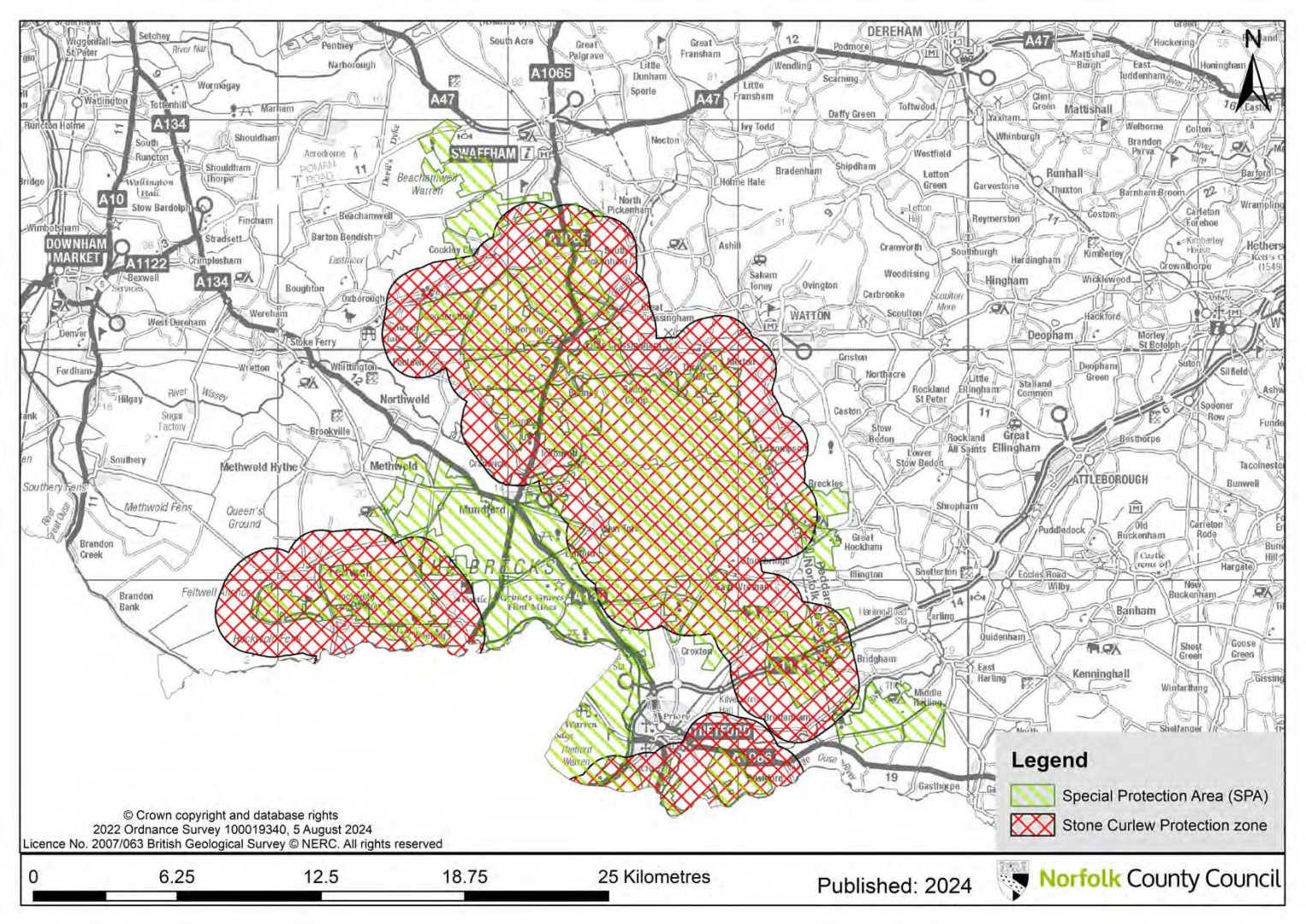
Map 2: Stone Curlew protection zones
9.3 In 2013 a "Further Assessments of the Relationship between Buildings and Stone Curlew Distribution" study was carried out by Footprint Ecology on behalf of Breckland Council to update previous work on the effect of buildings and roads on Stone Curlews in The Brecks. Including new analysis and using additional survey data, this study report focused on the effects of buildings on the distribution of breeding Stone Curlew in The Brecks. The report provides strong support for the continuation of a 1,500m zone around the areas capable of supporting Stone Curlews.
9.4 Stone Curlews are also found outside of the SPA. Stone Curlew are a protected species listed in Schedule 1 of the Wildlife and Countryside Act 1981 so any direct or indirect impacts (such as disturbance up to 1,500m away) to non-SPA stone curlew will still need to be assessed and if necessary mitigated / compensated for outside of the Habitats Regulations process.
9.5 The 2013 research also suggests that the planting of woodland/screening as a mitigation measure is unlikely to be effective and that the effect of nest density is strongest as a result of the amount of buildings. One of the key aims of the research was to differentiate the effects of nest density due to different building classes. The research indicates that the effect of buildings is from residential rather than other building types. However, due to the sample size and number of buildings identified, there needs to be an element of caution applied to the results. As such, proposed non-residential building developments in the 1,500m buffer zone should be carefully considered. Any project level HRA undertaken should ensure it can demonstrate adverse effects can be ruled out.
Policy MW4: The Brecks Protected Habitats and Species
The Council will require suitable information to be provided to enable it to undertake a Habitats Regulations Assessment of all proposals for development that are likely to have a significant effect on the Breckland Special Protection Area (SPA), which is designated for its populations of Stone Curlew, Woodlark and Nightjar, and/or Breckland Special Area of Conservation (SAC) which is designated for its heathland habitats amongst other features. Development will only be permitted where sufficient information is submitted to demonstrate that the proposal will not adversely affect the integrity of the SPA or SAC.
Stone Curlew
A buffer zone has been defined (indicated in red hatching on Map 2) that extends 1,500m from the edge of those parts of the SPA that support or are capable of supporting Stone Curlew, where new built development maybe likely to significantly affect the SPA population.
Built development (including plant and processing sites) within the SPA boundary, will not normally be permitted, unless a project level HRA is able to demonstrate that adverse effects can be ruled out.
Where a proposed building is outside the SPA but within 1,500m of the SPA boundary (see Map 2) or areas considered functionally linked, there may be circumstances where a project level Habitats Regulations Assessment is able to demonstrate that the proposal will not adversely affect the integrity of the SPA.
Circumstances where the proposal is able to conclusively demonstrate that it will not result in an adverse effect on the Breckland SPA may include where the proposal is:
- More than 1,500m away from potential stone curlew nesting sites inside the SPA; however, these proposals will still need to assess direct and indirect impacts to stone curlew as a protected species under the Wildlife and Countryside Act 1981;
- A proposed re-development of an existing building that would not alter its footprint or increase its potential impact.
Woodlark and Nightjar
Built development (including plant and processing sites) within 400m of the SPA that support or are capable of supporting Woodlark and/or Nightjar will not normally be permitted.
The Council will consider the need for a Habitats Regulations Assessment to determine the implications of development on Nightjar and Woodlark on a case-by-case basis, depending on the location and nature of the proposal.
10. Agricultural soils
10.1 Norfolk is predominately rural in nature and agriculture plays a significant role in the local economy and heritage. Continuing to preserve good quality agricultural land is important as it will benefit the economy as well as Norfolk's landscape. Agricultural land is divided into five grades as follows: Grade 1 – excellent quality
Grade 2 – very good quality
Grade 3 – good to moderate quality
Sub-grade 3a – good quality
Sub-grade 3b – moderate quality
Grade 4 – poor quality
Grade 5 – very poor quality
10.2 The Best and Most Versatile (BMV) Agricultural Land consists of grades 1, 2 and 3a. The NPPF (paragraph 181, December 2023) states that "where significant development of agricultural land is demonstrated to be necessary, areas of poorer quality land should be preferred to those of a higher quality". However, minerals development is, in almost all cases, a temporary use of land, followed by restoration. It is therefore normally possible to remove and store topsoils and subsoils during an operational phase, and then to replace them afterwards to bring a site back into agricultural use, if appropriate.
10.3A soils management and handling strategy must be submitted to the County Planning Authority for applications where development is proposed on agricultural land. The strategy should contain a comprehensive soil assessment including a detailed soil survey to identify soil types, profiles and depths and details to demonstrate how the proposal will undertake any soil operations including stripping, storage and replacement.
10.4 Grade 1 soils are a vital national resource and Norfolk contains some significant areas of Grade 1 land, particularly in the peaty soils of the Fenland area and the Broads. Grade 2 soils are distributed more widely across the county, albeit in smaller patches, but Grade 3 soils make up the majority of Norfolk's agricultural land. The subgrades of 3a and 3b agricultural land are not mapped, at a national level, and therefore it is only possible to differentiate between them by carrying out a detailed site survey of soil quality. It is only as surveys on individual landholdings are carried out that 3a and 3b are differentiated. Grade 4 land occurs in smaller areas, located mainly in the drier and more free-draining Brecks. There are only 110 hectares of Grade 5 agricultural land in Norfolk which is all located either within or adjacent to the Breckland SPA, therefore there is no policy preference for locating minerals or waste development on Norfolk's Grade 5 agricultural land.
10.5 As detailed in Policy WP3, waste management facilities should be suitably located on previously developed land or on land allocated or permitted for general industrial use or storage and distribution use. Therefore, it is not normally appropriate to locate waste management facilities on agricultural land. However, where a waste management facility is proposed on BMV agricultural land, policy MW5 will still apply.
Policy MW5: Agricultural soils
Where development is proposed on agricultural land, the County Council has a clear preference for locating new mineral extraction and associated activities, and composting facilities, on land of agricultural grades 3b and 4.
Development proposals affecting Grade 1 agricultural land will only be permitted in exceptional circumstances, where it is demonstrated that there are no alternative locations for the development.
In addition to the above, when minerals development, particularly extraction, is proposed on agricultural land of grades 1, 2 or 3a it will only be permitted where:
- Provision is made for high standards of soil management that would enable restoration to a condition at least as good as its previous agricultural quality. To demonstrate this, soil and land quality surveys, and soil handling and replacement strategies (based upon Institute of Quarrying's 'Good Practice Guide for Handling Soils in Mineral Workings (2021)) must be submitted to the County Planning Authority; or
- The benefit of restoring the land to another after-use can be shown to outweigh the loss of the agricultural use of the land.
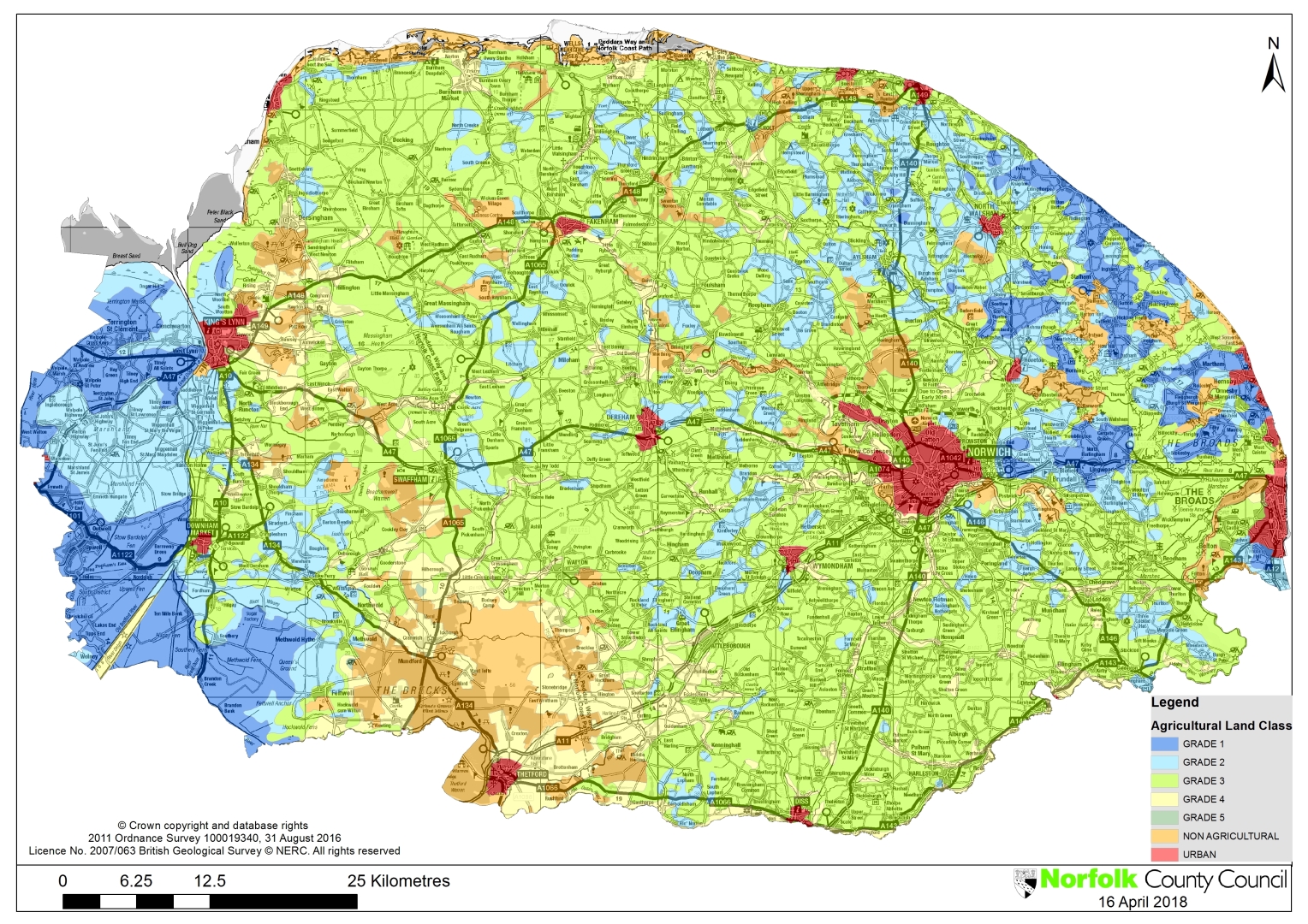
Map 3: Agricultural land grades