Preferred Options consultation document
MINERALS SPECIFIC POLICIES
30. Provision for minerals extraction – STRATEGIC POLICY
MP1.1 The NPPF states that Mineral Planning Authorities should plan for a steady and adequate supply of aggregates. The aggregates that are extracted within Norfolk are sand and gravel, and carstone.
Sand and gravel requirements and shortfall
MP1.2 The average sand and gravel production in Norfolk over the last 10 years (2009–2018) was 1.361 million tonnes per annum.
MP1.3 The NPPG suggests the use of 3-year average figures to indicate recent trends in sales. The average sand and gravel production in Norfolk over the last three years (2016-2018) was 1.580 million tonnes per annum and shows a recent upward trend and production levels above the 10-year average.
MP1.4 Average sand and gravel production over the last 20 years was 1.868 million tonnes per annum.
MP1.5 The NPPG suggests that the 10-year rolling average, 3 year rolling average and the sub-national guidelines should all be considered in order to establish a broad understanding of current and future mineral demand, especially during reviews of planned provision. The sub-national guidelines are for Norfolk to produce 2.57 million tonnes of sand and gravel a year. However, in the last 10 years (2009-2018) this has not been reflected in the actual sand and gravel production in Norfolk, which was an average of only 1.361 million tonnes per annum.
MP1.6 It is considered that planning to provide the 20-year average annual production figure would enable a sufficient quantity of sand and gravel resources to be available over the 18-year plan period and would take into account potential fluctuations in the economy.
MP1.7 Over the 18-year plan period to 2036, using the 20-year average of 1.868 million tpa, 33.624 million tonnes of sand and gravel resources would be needed in total. Taking into account the existing permitted reserve, the remaining need for allocated sites is 20.313 million tonnes of sand and gravel.
MP1.8 The current permitted reserve of sand and gravel at 31/12/2018 is 13,310,700 tonnes. The permitted reserve therefore currently provides a landbank of more than 7 years' worth of sand and gravel production as required by the NPPF.
|
A |
Forecast need for sand and gravel from 2019-2036 (1,868,000 tonnes per year x 18 years) |
33,624,000 tonnes |
|
B |
Sand and gravel permitted reserve at 31/12/2018 |
13,310,700 tonnes |
|
C |
Total shortfall (A-B) and therefore minimum quantity to be allocated |
20,313,300 tonnes |
|
The total shortfall of 20,313,300 tonnes is equivalent to a need for 10.9 years' further supply over the period of the Minerals and Waste Local Plan Review. |
||
MP1.9 In addition to land won aggregates, secondary and recycled aggregates are also sourced within Norfolk. Data for the production of recycled and secondary aggregates is limited, and less reliable than for other types of aggregate. The annual average quantity of inert and construction/demolition waste recovered at waste management facilities over the ten years from 2008-2017 was 413,900, however, some parts of this waste stream are unsuitable for use as a recycled aggregate (such as soil or timber). The data is not comprehensive because many operations, such as on-site recovery, are not recorded. Therefore, it is not proposed to make any adjustments to the mineral requirement figures based on recycled and secondary aggregate provision due to the quality of the data.
MP1.10 A total of less than 500 tonnes of marine sourced aggregates was consumed in Norfolk in 2014 (the most recently available data) and represents such a small percentage of the total aggregates used in Norfolk it is not proposed to make any adjustments to the mineral requirement figures due to marine sourced aggregates.
Carstone requirement and shortfall
MP1.11 The NPPG suggests that the 10-year rolling average, 3-year rolling average and the sub-national guidelines should all be considered in order to establish a broad understanding of current and future mineral demand, especially during reviews of planned provision. The sub-national guidelines are for Norfolk to produce 200,000 tonnes of carstone a year. However, in the last 10 years (2009-2018) this has not been reflected in the actual carstone production in Norfolk, which was an average of 78,023 tonnes per annum.
MP1.12 The average carstone production over the last 20 years was 121,443 tpa.
MP1.13 The average carstone production in Norfolk over the last three years (2016-2018) was 103,431 tonnes per annum. The production of carstone in Norfolk is concentrated into relatively few workings and the production fluctuates significantly from year to year dependent on individual construction projects that require significant fill material. These fluctuations mean that the three-year rolling average can also vary significantly year to year; this means that it is of less value in helping to identify production trends for carstone.
MP1.14 Therefore, it is considered that planning to provide the 20-year average annual production figure would enable a sufficient quantity of carstone resources to be available over the 18-year plan period and would take into account potential fluctuations in the economy.
MP1.15 The current permitted reserve of carstone, at 31/12/2018 is 1,845,000 tonnes. The permitted reserve therefore currently provides a landbank of more than 10 years' worth of carstone production, as required by the NPPF.
MP1.16 Over the 18-year plan period to 2036, using the 20-year average of 121,400 tpa, a total of 2,185,200 tonnes of carstone resources would be needed. Taking into account the existing permitted reserve, the remaining need for allocated sites is 377,500 tonnes.
|
A |
Forecast need for carstone from 2019 – 2036 (121,400 tonnes per year x 18 years) |
2,185,200 tonnes |
|
B |
Carstone permitted reserve at 31/12/2018 |
1,845,000 tonnes |
|
C |
Total shortfall (A-B) and therefore minimum quantity to be allocated |
340,200 tonnes |
|
The total shortfall of 340,200 tonnes is equivalent to a need for 2.8 years' further supply over the period of the Minerals and Waste Local Plan Review. |
||
Silica sand requirement and shortfall
MP1.17 The NPPF states that Minerals Planning Authorities should plan for a steady and adequate supply of industrial minerals. The industrial mineral that is extracted in Norfolk is silica sand which is used for the manufacture of glass. The silica sand is processed at an existing plant site, operated by Sibelco UK Ltd, which is located at Leziate. The processing plant site includes a rail head to export the processed mineral for use by glass manufacturers elsewhere.
MP1.18 The NPPF states that the supply of silica sand should be planned as years' worth of production for the plant within a Mineral Planning Authority's area. The stock of permitted reserves of silica sand should be at least 10 years' production for individual silica sand sites, and if significant new capital is required, then stocks for at least 15 years production should be planned for.
MP1.19 The average silica sand production in Norfolk over the last 10 years (2009-2018) was 721,117 tonnes per annum. The average silica sand production in Norfolk over the last 3 years (2016-2018) was 803,587 tonnes per annum.
MP1.10 A 20-year average production figure is not available for silica sand, however, based on the information available for 10-year and 3-year production averages (provided since 2013 and 2009 respectively), it is considered appropriate to continue to plan for an annual production of 750,000 tonnes per annum.
MP1.11 The current permitted reserve of silica sand, at 31/12/2018 is 3,000,000 tonnes. The permitted reserve therefore provides a landbank of less than 10 years' worth of silica sand production, which is below the level required by the NPPF. However, the permitted reserve is dependent upon the submission of suitable planning applications and the most recent planning application for a new silica sand extraction site in Norfolk was determined and granted in 2007. An application for a new silica sand extraction site in Norfolk was received in 2018 and is currently in the process of being determined.
|
A |
Forecast need for silica sand from 2019-2036 (750,000 tonnes per year x 18 years) |
13,500,000 tonnes |
|
B |
Silica sand permitted reserve at 31/12/2018 |
3,000,000 tonnes |
|
C |
Total shortfall (A-B) and therefore minimum quantity to be allocated |
10,500,000 tonnes |
|
The total shortfall of 10,500,000 tonnes is equivalent to a need for 14 years' further supply over the period of the Minerals and Waste Local Plan Review. |
||
Other minerals
MP1.12 Clay and chalk are also extracted in Norfolk. However, the resource for these minerals is considered to be abundant in Norfolk relative to the demand.
MP1.13 There is no national policy requirement to maintain a landbank for clay or chalk and therefore it is considered that there is no need to allocate additional sites for these minerals over the plan period. Any planning applications coming forward for clay or chalk extraction will be considered on their merits.
MP1.14 The NPPF states that Local Plans should not identify new sites or extensions to existing sites for peat extraction.
Policy MP1: Provision for minerals extraction – STRATEGIC POLICY
The strategy for minerals extraction is to allocate sufficient sites to meet the forecast need for both sand & gravel and hard rock (carstone).
For sand and gravel, specific sites to deliver at least 20,313,300 tonnes of resources will be allocated. The sand and gravel landbank will be maintained at a level of at least 7 years' supply (excluding any contribution from borrow pits for major construction projects).
Mineral extraction for sand and gravel outside of allocated sites will be resisted by the Mineral Planning Authority unless the applicant can demonstrate:
- There is an overriding justification and/or overriding benefit for the proposed extraction, and
- The proposal is consistent with all other relevant policies set out in the Development Plan.
For carstone, a site or sites to deliver at least 340,200 tonnes of resources will be allocated. The landbank for carstone will be maintained at a level of at least 10 years' supply.
For silica sand, sufficient sites and/or areas to deliver at least 10,500,000 tonnes of silica sand will be allocated. The landbank for silica sand will be maintained at a level of at least 10 years' supply where practicable. Planning applications for silica sand extraction located outside of allocated sites or areas of search, which would address the shortfall in permitted reserves, will be determined on their own merits in accordance with the policies in this Local Plan, including the requirements contained within Policy MP13.
MP1.15 National guidance sets the Plan at the heart of the planning system with a statutory requirement that planning decisions are taken in accordance with the plan unless material considerations indicate otherwise.
MP1.16 Paragraph 15 of the NPPF states that the planning system should be genuinely plan-led and provide a framework for addressing need and other economic, social and environmental priorities. To ensure future sand and gravel extraction is clearly focused on the Spatial Strategy and the identified allocated sites in this Plan, other proposals for sand and gravel extraction at locations situated outside of the areas identified for future working will normally be resisted by the Mineral Planning Authority (MPA). There may, however, be circumstances where an 'over-riding justification' and/ or over-riding benefit for mineral development can be demonstrated. Mineral extraction on unallocated sites may occur in relation to:
- Agricultural irrigation reservoirs – where mineral is extracted and exported to create the reservoir landform,
- Borrow pits – where extraction takes place over a limited period for the exclusive use of a specific construction project such as for a specific road scheme,
- Prior extraction to prevent mineral sterilisation – this may be required on occasions where significant development takes place (on a site of over 2 hectares) and where a workable mineral resource could otherwise be permanently lost through sterilisation.
MP1.17 Such proposals will be considered on their own individual merits and the MPA will pay particular regard to the justification/ need that is cited by applicants when determining planning applications. The MPA must be satisfied that there are exceptional reasons for permitting such applications, after having considered all the relevant circumstances so as not to prejudice the overall strategy of the document. All proposals will be considered against policies in the Development Plan.
MP1.18 Where proposals are put forward on the basis of fulfilling some form of 'mineral need' for minerals extraction, then the MPA will always require consideration of the whole of the County for the purposes of estimating the adequacy of the landbank or the sufficiency of the Plan's provision. The MPA does not consider that information about mineral supply in specific County sub-areas, or the individual commercial business need of a mineral operator to continue production at a particular mineral extraction site, to be relevant or material to its decisions in respect of unallocated Sites.
MP1.19 Due to only two specific sites (containing an estimated mineral resource of 4.2 million tonnes) being found suitable to allocate for silica sand extraction, along with the uncertainty regarding the potential development for silica sand extraction within the allocated areas of search, flexibility has been provided within Policy MP1 to enable planning applications for silica sand extraction which would address the shortfall in permitted silica sand reserves, to be considered on their own merits, even if they are located outside of an allocated specific site or area of search. The silica sand areas of search are based on the Norfolk Mineral Resources Map, published by the British Geological Survey (BGS), which shows inferred mineral resources based on limited borehole testing. Therefore, it may be possible for suitable sites to be proposed outside of the areas of search where further borehole testing results demonstrate a viable mineral resource.
Alternative options:
MP1.20 The proposed policy for sand and gravel and carstone is to allocate sufficient sites to meet the forecast need over the plan period based on the average production figures over the last 20 years. The alternative options would be to use the average production figures for the last 10 years, or to use the sub-national guidelines, as follows:
Option 1
MP1.21 An alternative option would be to use the average production figures from the last 10 years to forecast the quantity of sand and gravel and carstone to be planned for. The 10-year average production for sand and gravel is 1,361,200 tpa and the 10-year average production figure for carstone is 78,023 tpa.
Sand and gravel
|
A |
Forecast need for sand and gravel from 2019-2036 (1,361,200 tonnes per year x 18 years) |
24,501,600 tonnes |
|
B |
Sand and gravel permitted reserve at 31/12/2018 |
13,310,700 tonnes |
|
C |
Total shortfall (A-B) to be allocated |
11,190,900 tonnes |
MP1.22 Using the 10-year sales average for sand and gravel would mean that sites for 11,190,900 tonnes of sand and gravel extraction would need to be allocated over the plan period. This is a lower requirement than contained in Policy MP1.
Carstone
|
A |
Forecast need for carstone from 2019 – 2036 (78,023 tonnes per year x 18 years) |
1,404,414 tonnes |
|
B |
Carstone permitted reserve at 31/12/2018 |
1,845,000 tonnes |
|
C |
Total shortfall (A-B) to be allocated |
0 tonnes |
MP1.23 Using the 10-year sales average for carstone would mean that no additional carstone extraction sites are required to be allocated over the plan period. This is a lower requirement than contained in Policy MP1. However, the current permitted reserve is contained in only two sites, which may not provide sufficient flexibility to meet any future increase in demand for carstone. Therefore, it is considered that for the plan to be positively prepared, a site for carstone extraction should be allocated.
MP1.24 In addition, the NPPF states that other relevant local information and an assessment of all supply options should also be taken into account when planning for a steady and adequate supply of aggregate. As the plan period covers 18 years, until 2036, it is considered that the twenty-year sales average is a more appropriate figure to use than the ten-year average because it covers both growth and recession periods in an economic cycle. Using the average sales figures from the last 10 years mainly covers a recession period in the economic cycle and is therefore considered to be less appropriate to use.
Option 2
MP1.25 The second alternative option would be to use the sub-national guidelines to forecast the quantity of sand and gravel and carstone to plan for. The existing policy CS1 (in the Minerals and Waste Core Strategy adopted in 2011) uses the sub-national guidelines. The sub-national guideline for sand and gravel is 2.57 million tpa and the sub-national guideline for carstone is 200,000 tpa.
Sand and gravel
|
A |
Forecast need for sand and gravel from 2019-2036 (2,570,000 tonnes per year x 18 years) |
46,260,000 tonnes |
|
B |
Sand and gravel permitted reserve at 31/12/2018 |
13,310,700 tonnes |
|
C |
Total shortfall (A-B) to be allocated |
32,949,300 tonnes |
MP1.26 Using the sub-national guidelines for sand and gravel would mean that sites for 32,949,300 tonnes of sand and gravel extraction would need to be allocated over the plan period. This is a higher requirement than contained in Policy MP1. However, production of sand and gravel has not met the sub-national guidelines at any time in the last 10 years. During the last 10 years sand and gravel production has only been between 39% and 63% of the sub-national guidelines. Therefore, the sub-national guidelines for sand and gravel are considered to be too high and not a reasonable alternative for the plan. In addition, the sub-national guideline figures only covered the period 2005-2020 and have not been updated, making these figures increasingly obsolete.
Carstone
|
A |
Forecast need for carstone from 2019 – 2036 (200,000 tonnes per year x 18 years) |
3,600,000 tonnes |
|
B |
Carstone permitted reserve at 31/12/2018 |
1,845,000 tonnes |
|
C |
Total shortfall (A-B) to be allocated |
1,755,000 tonnes |
MP1.27 Using the sub-national guidelines for carstone would mean that sites for 1,755,000 tonnes of carstone extraction would need to be allocated over the plan period. This is a higher requirement than contained in Policy MP1. However, production of carstone has not met the sub-national guidelines at any time in the last 10 years. During the last ten years carstone production has only been between 19% and 59% of the sub-national guidelines. Therefore, the sub-national guidelines for carstone are considered to be too high and not a reasonable alternative for the plan. In addition, the sub-national guideline figures only covered the period 2005-2020 and have not been updated, making these figures increasingly obsolete.
Silica sand
MP1.28 There are no sub-national guidelines for silica sand extraction and therefore this is not an alternative forecasting option. As there is no requirement for the silica sand extraction companies to provide annual figures of silica sand production we do not have a twenty-year sales average figure to use and this is not an alternative forecasting option. Therefore, the ten-year and three-year sales averages which have been provided to Norfolk County Council have been used to determine an appropriate figure to use to forecast the future need for silica sand extraction over the plan period, as contained in Policy MP1.
31. Spatial strategy for minerals extraction – STRATEGIC POLICY
MP2.1 The Key Diagram and Policy MP2 below set out a spatial strategy for minerals development within Norfolk. These following factors have been considered in the spatial strategy for minerals:
- minerals can only be worked where they occur;
- crushed rock is imported, primarily by rail from outside of the County via rail heads located at Norwich, Snetterton and Brandon;
- marine borne crushed rock is landed at a wharf at Great Yarmouth for onward transport by road;
- the nearest location where marine dredged sand and gravel aggregates are landed is at Ipswich docks in Suffolk;
- aggregates recycling facilities should be located with suitable access to the road network and in proximity to centres of population and therefore sources of waste;
- the Norfolk Route Hierarchy provides a recognised hierarchy of roads. HGVs should take the shortest practicable route (avoiding inappropriate junctions and travel through settlements where possible) to access the strategic highway network at the earliest appropriate point;
- significant areas of the County are within the statutory landscape designations of the Norfolk & Suffolk Broads, and the Norfolk Coast Area of Outstanding Natural Beauty;
- significant areas of the County are within statutory ecological designations of Ramsar, Special Protection Areas, Special Areas of Conservation and Sites of Special Scientific Interest;
- the county's larger settlements will be the locations of greatest housing and employment growth in Norfolk during the Plan period
- the existing processing plant for silica sand is located at Leziate.
MP2.2 Mineral deposits can only be extracted where they occur, so the spatial strategy for mineral extraction is prescribed to a large extent by the geological distribution of mineral resources within Norfolk. The Norfolk Mineral Resources Map, published by the British Geological Survey (BGS), as amended by the BGS DiGmapGB-50 dataset, includes a breakdown of mineral types and distribution. The key diagram shows the location of the sand and gravel, carstone and silica sand resources in Norfolk; it also shows the location of currently operational mineral extraction sites.
MP2.3 The key diagram shows that sand and gravel resources are abundant and located widely in Norfolk, with the exception of the Fens area in west Norfolk, although the ratio of sand to gravel varies significantly. Carstone and silica sand deposits are located in very limited areas of Norfolk, with both resources only occurring in a north/south band in west Norfolk. Specific site allocations, preferred areas and/or areas of search for future mineral extraction will be identified based on these resource areas.
MP2.4 Silica sand is mostly exported out of Norfolk, by train, for glass production elsewhere. Therefore, within the confines of the available mineral resource, the spatial preference for new silica sand extraction sites is for sites which would be able to access the existing processing plant and railhead at Leziate via conveyor, pipeline or off-public highway routes.
MP2.5 Sand and gravel is used in the
construction of roads and buildings and is a key ingredient
in the production of concrete and mortar, asphalt coating for
roads, as a drainage medium and in the construction of
embankments and foundations. Norfolk's urban areas and main
towns are the locations where there will be the greatest need
for a supply of aggregate for new housing developments and
associated infrastructure.
MP2.6 The settlement hierarchy is defined by the Local Planning Authorities in Norfolk. The urban areas and main towns are:
Urban Areas: Norwich, King's Lynn (including West Lynn), Thetford, Attleborough, Great Yarmouth and Gorleston-on-Sea
The Norwich urban area includes the built-up parts of the urban fringe parishes of Colney, Costessey, Cringleford, Trowse, Thorpe St Andrew, Sprowston, Old Catton, Hellesdon, Drayton and Taverham.
Main Towns: Aylsham, Cromer, Dereham, Diss, Downham Market, Fakenham, Harleston, Holt, Hunstanton, North Walsham, Swaffham, Watton, Wymondham
MP2.7 The landscape designations of the Norfolk Coast AONB and the Broads Authority Executive Area are shown on the Key Diagram and the Policies Map along with the national and international ecological designations of Ramsar sites, SPAs, SACs and SSSIs. Some of these landscape and ecological designations occur in proximity to Norfolk's urban areas and main towns.
MP2.8 The National Planning Practice Guidance states that mineral planning authorities should plan for the steady and adequate supply of minerals in one or more of the following ways (in order of priority):
- designating Specific Sites – where viable mineral resources are known to exist, landowners are supportive of minerals development and the proposal is likely to be acceptable in planning terms. Such sites may also include essential operations associated with mineral extraction;
- designating Preferred Areas, which are areas of known mineral resources where planning permission might reasonably be anticipated. Such areas may also include essential operations associated with mineral extraction; and/or
- designating Areas of Search – areas where knowledge of mineral resources may be less certain but within which planning permission may be granted, particularly if there is a potential shortfall in supply.
MP2.9 Designating specific sites in minerals plans provides the most certainty on when and where development may take place. The better the quality of data available to Mineral Planning Authorities, the better the prospect of a site being designated as a Specific Site.
MP2.10 Due to the need to address a predicted shortfall in the quantity of allocated silica sand extraction sites, four areas of search for silica sand extraction were designated; in addition to an additional specific site allocation; as part of the Single Issue Silica Sand Review of the Minerals Site Specific Allocations DPD, which was adopted in December 2017. In addition to allocating specific sites and/or preferred areas for silica sand extraction, to provide some flexibility, we propose to continue to designate the same four areas of search for future silica sand extraction as part of the Minerals and Waste Local Plan Review. The areas of search are large areas within which planning permission for silica sand extraction may be granted on a smaller area of land. The methodology used to define the areas of search is included in Policy MP2 and explained in the following paragraphs.
Defining Areas of Search
MP2.11 Areas of Search for silica sand extraction, of at least 20 hectares in size, will be defined from within the Leziate Beds silica sand resource, excluding the following planning constrains:
a. Norfolk Coast Area of Outstanding Natural Beauty: The Norfolk Coast AONB is a statutory national designation with the purpose of the conservation and enhancement of natural beauty. The NPPF (paragraph 172) states that "Planning permission should be refused for major developments in these designated areas except in exceptional circumstances, and where it can be demonstrated that the development is in the public interest." It is therefore not considered appropriate for the areas of search to include the AONB.
b. ancient woodland sites and 250 metres around them: The NPPF classifies ancient woodland as an irreplaceable habitat and states (in paragraph 175b) that: "development resulting in the loss or deterioration of irreplaceable habitats (such as ancient woodland and ancient or veteran trees) should be refused, unless there are wholly exceptional reasons and a suitable compensation strategy exists".
An area of 250 metres surrounding each ancient woodland site has also been excluded from the areas of search. This distance has been used because uncontrolled dust can have a significant effect on ancient woodland habitats and it is considered that 250 metres would allow for the mitigation of dust with the minimum of controls. A planning application may be able to provide information to support an acceptable distance closer than this, but 250 metres is considered appropriate for an Area of Search. It is recognised that impacts on local hydrology from mineral extraction may occur at a distance greater than 250 metres from an ancient woodland, and any subsequent planning application within an area of search will need to address this.
c. SSSIs and 250 metres around them: All NNRs, SPAs, SACs and Ramsar sites are also SSSIs. Therefore, excluding all SSSIs and 250 metres around them, means that all NNRs, SPAs, SACs and Ramsar sites have also been excluded from the areas of search. SSSIs are designated and protected at a national level. Paragraph 175 (b) of the NPPF states that: "development on land within or outside a SSSI, and which is likely to have an adverse effect on it (either individually or in combination with other developments) should not normally be permitted".
An area of 250 metres around each SSSI has been excluded from the areas of search because at this it is considered that this distance would allow for the mitigation of dust and noise with the minimum of controls. However, it is recognised that the special biological or geological features of interest for which each SSSI has been notified will vary from site to site and the vulnerabilities of these features will also vary. This variation means that the impacts from mineral extraction, including the distance at which an impact may occur, will differ between each SSSI. A number of the SSSIs which occur within 5km of the silica sand resource are vulnerable to changes in water flow and levels. Any subsequent planning application within an area of search will need to assess the impact of mineral extraction on SSSIs.
d. 1km around The Wash SSSI
The Wash is designated as a SSSI, SAC, SPA and Ramsar site. Therefore this site is protected at national, European and international level from development that would be likely to have a significant effect on their important interest features. Potential adverse impacts from mineral extraction could be dust emissions, noise and visual disturbance, physical habitat loss, physical damage, impacts to water quality, and the loss of functional habitat used by the designated bird species of The Wash for foraging. Some of these impacts could be mitigated through the design and operation of a mineral extraction operation. However, it is considered that by excluding land within 1km of The Wash SSSI, mineral extraction would be unlikely to have an adverse effect on the integrity of the SPA, SAC or Ramsar site. Any subsequent planning application within an area of search located within the Impact Risk Zone for The Wash SSSI will need to assess the impact of mineral extraction on The Wash SSSI, SAC, SPA and Ramsar site.
e. The hydrological catchment around Roydon Common SSSI and Dersingham Bog SSSI: Roydon Common and Dersingham Bog are designated as SSSIs, NNRs, SAC and Ramsar sites. Therefore, these sites are protected at national, European and international level from development that would be likely to have a significant effect on their important interest features. Roydon Common and Dersingham Bog are sensitive and vulnerable to changes in water flow and levels and water chemistry. Natural England therefore recommend avoiding the hydrological catchment areas for Roydon Common and Dersingham Bog when defining areas of search.
f. Registered Common Land: Legislation protects the activities which can and cannot be carried out on registered common land. Therefore, it would not be appropriate for common land to be included with the areas of search for mineral extraction.
g. Designated heritage assets (Listed Buildings, Scheduled Monuments, registered historic parks and gardens, Conservation Areas) and 250 metres around each heritage asset:
Listed Buildings, Scheduled Monuments and registered historic parks and gardens are designated at a national level by Historic England. Conservation Areas are designated by the local planning authority and usually contain a number of Listed Buildings within them. The NPPF (paragraph 194) states that "substantial harm to or loss of: a) grade II listed buildings, or grade II registered parks or garden should be exceptional; b) assets of the highest significance, notably scheduled monuments, … grade I and II* listed buildings, grade I and II* registered parks and gardens, … should be wholly exceptional".
An area of 250 metres around designated heritage assets has been excluded from the areas of search. This 250-metre area is not intended to be the setting of the heritage asset and it is recognised that the extent of the setting of each heritage asset will be different and may extend more or less than 250 metres from the heritage asset. The setting of a heritage asset contributes to the significance of the heritage asset. The 250-metre stand-off is a starting point for where mineral extraction may be generally acceptable when the setting and significance of heritage assets is taken into account. The likelihood that mineral operations would be unacceptable in principle, or subject to such significant mitigation requirements as make the working undeliverable, generally increase with proximity. Any subsequent planning application within an area of search would need to provide a Heritage Statement if the proposal could potentially impact upon a heritage asset or its setting, which would provide the necessary detail.
h. Sensitive receptors to amenity impacts (residential dwellings, educational facilities, workplaces, healthcare and leisure facilities) and 250 metres around each sensitive receptor: An area of 250 metres around sensitive receptors has been excluded because this represents a distance at which amenity impacts (such as noise and dust) could be mitigated to acceptable levels with the minimum of controls. A planning application may be able to provide information to support mineral extraction closer than 250 metres from a sensitive receptor, but 250 metres is considered appropriate for an area of search.
i. Agricultural land grades 1 and 2: Grades 1 and 2 are defined nationally as the highest quality agricultural land and the NPPF (footnote 53) contains requirements to ensure that the Best and Most Versatile (BMV) agricultural land is safeguarded. "Where significant development of agricultural land is demonstrated to be necessary, areas of poorer quality land should be preferred to those of a higher quality". Grade 3 agricultural land has not been excluded from the areas of search because only subgrade 3a is classified as BMV agricultural land. The subgrades of 3a and 3b are not mapped and therefore it is not possible to differentiate between them when defining the areas of search.
j. Allocated, current and restored mineral extraction sites: Additional silica sand resources will not be found within sites where mineral extraction has already been completed.
MP2.12 The purpose of defining areas of search for future silica sand extraction is to provide sufficient locations suitable for the production of glass sand, as required by the existing processing facility at Leziate. The majority of previous extraction of silica sand for glass manufacture has taken place from the Leziate Beds and this deposit has the highest probability of providing deposits of a suitable quality and grade for this use.
MP2.13 Based on planning permissions for previous extraction sites, it is considered unlikely that a commercial silica sand extraction operation would take place on less than 20 hectares of land. Therefore, areas of search below 20 hectares in size are unlikely to be deliverable.
MP2.14 Sites and/or areas for the extraction of sand and gravel, carstone, and silica sand during the Plan period to 2036 will be allocated as part of the Minerals and Waste Local Plan Review process. Developers wanting to extraction mineral from specific sites or land within an area of search allocated in the Minerals and Waste Local Plan Review will still need to apply for and be granted planning permission before mineral extraction can take place.
Policy MP2: Spatial Strategy for mineral extraction – STRATEGIC POLICY
Within the resource areas identified on the key diagram, specific sites for sand and gravel or carstone extraction should be located within five miles of one of Norfolk's urban areas or three miles of one of the main towns (detailed in the supporting text) and/or be well-related to one of Norfolk's urban areas or main towns via appropriate transport infrastructure.
Within the resource areas identified on the key diagram, specific sites or preferred areas for silica sand extraction should preferably be located where they are able to access the existing processing plant and railhead at Leziate via conveyor, pipeline or off-public highway routes.
Areas of Search for silica sand extraction, of at least 20 hectares in size, will be defined from within the Leziate Beds silica sand resource, excluding the following planning constraints:
- Norfolk Coast Area of Outstanding Natural Beauty
- ancient woodland sites and 250 metres around them
- SSSIs and 250 metres around them
- 1km around The Wash SSSI
- The hydrological catchment around Roydon Common SSSI and Dersingham Bog SSSI
- Registered Common Land
- Designated heritage assets (Listed Buildings, Scheduled Monuments, registered historic parks and gardens, Conservation Areas) and 250 metres around each heritage asset
- Sensitive receptors to amenity impacts (residential dwellings, educational facilities, workplaces, healthcare and leisure facilities) and 250 metres around each sensitive receptor
- Agricultural land grades 1 and 2
- Allocated, current and restored mineral extraction sites
The designated areas of search for silica sand extraction will be those parts of the silica sand resource which are least constrained based on the above criteria; where a suitable future planning application for silica sand extraction may be approved.
MP3. Borrow pits
MP3.1 A 'borrow pit' is a temporary mineral working to supply material for a specific construction project. Major construction projects, especially road schemes, can demand considerable quantities of aggregate, particularly low grade fill material. In some cases this can be sourced near to major construction projects, which can have advantages over established extraction sites, by reducing the impact of concentrated flows of heavy goods traffic on the public highway. A proposal of this nature must be able to demonstrate that it represents the most appropriate source of mineral to meet the additional demand.
Policy MP3: Borrow pits
Borrow pits will be permitted so long as the applicant can demonstrate that:
- The borrow pit will only be used in connection with a major construction project with which it is associated; and
- The pit is the most appropriate source of mineral to meet the additional demand; and
- The pit can be accessed from the construction project site either directly or via a short length of suitable highway; and
- The scale of the extraction is no more than the minimum essential for the purpose of the project; and
- It will be worked and restored, by the completion of the related construction project; and
- Material will not be imported to the borrow pit other than from the project itself, unless such material is required to achieve beneficial restoration; and
- Extraction from the site causes less environmental damage than would result from using material from an established source of supply; and
- Proposals comply with the development management criteria in Policy MW2.
MP4. Agricultural or potable water reservoirs
MP4.1 Proposals for new reservoirs, or extensions to existing reservoirs with incidental mineral extraction, involving removal of sand and gravel off-site, will need to demonstrate that there is a proven need for the reservoir proposed at the given location. Such need could be demonstrated by, for instance, the Environment Agency agreeing that a proposal for a winter-fill agricultural reservoir or potable water reservoir is justifiable and acceptable.
Policy MP4: Agricultural or potable water reservoirs
Proposals for agricultural reservoirs, potable water reservoirs with incidental mineral extraction involving off-site removal of minerals will be permitted, so long as the applicant can demonstrate that:
- there is a proven need for the reservoir proposed at the given location; and
- the scale of the extraction is no more than the minimum essential for the purpose of the proposal; and
- the phasing and duration of development adequately reflects the importance of the early delivery of water resources or other approved development; and
- the proposal complies with the development management criteria set out in Policy MW2.
MP5. Core River Valleys
MP5.1 Norfolk's river valleys constitute a very important and valued element of Norfolk's landscape character, ranging from the fast-flowing chalk streams of the north-west of the county feeding to the Wash (such as the River Bablingley), slow-flowing rivers draining to the north Norfolk coast (such as the River Glaven) and the larger rivers of the Broads area (such as the rivers Bure, Yare, Wensum and Waveney). The county's river valleys were surveyed by Norfolk County Council during the 1990s to identify, in landscape terms, the areas considered to be core to the character of the river valley landscape. The Core River Valleys normally include the floodplains of the rivers and their major tributaries but in some cases the core areas also include the lower valley slopes where these are clearly defined, such as where grazing land extends up to a hedge or tree line on the valley sides.
MP5.2 The Core River Valleys in Norfolk and their associated grazing pastures offer a marked landscape contrast to the more common, intensively cultivated farmland and are vital ecological habitats and corridors, supporting a variety of biodiversity habitats and species. In this respect, Core River Valleys are a key component in the development of Norfolk's identified Green Infrastructure corridors.
MP5.3 Sand and gravel resources are commonly found in river valleys and many of Norfolk's river valleys have therefore been quarried for aggregate extensively over many years. This has led to many large bodies of open water left on restoration of past mineral workings which are not in keeping with the general character of Norfolk's river valleys.
MP5.4 Although not formally designated, safeguarding the Core River Valleys will help preserve the unique and rich quality of Norfolk's landscape and natural heritage.
Policy MP5: Core River Valleys
Minerals development will only be permitted in Core River Valleys (as shown on the Policies Map) where the applicant demonstrates that the development will:
- enhance the form, local character and local distinctiveness of the landscape; and
- enhance the biodiversity of the river valley (either immediately or on restoration); and
- not impede floodplain functionality.
An assessment of any impacts from mineral development will include:
- consideration of the potential impacts or enhancement of the landscape and natural environment, both during and after working;
- the duration of any adverse impacts, and mitigation and/or compensatory measures, as appropriate, to replace losses; and
- the provision of any long-term asset enhancement through restoration proposals.
MP6. Cumulative impacts and phasing of workings
MP6.1 Minerals can only be worked where they occur. Where viable mineral deposits are present, sometimes more than one mineral company may wish to exploit them at sites which are closely located. This can increase the impacts of operations to an extent that they become unacceptable. It is therefore important to ensure that, where there are a number of sites proposed close together or new sites proposed close to existing operations, the potential cumulative impacts are considered fully and satisfactorily mitigated.
MP6.2 Mitigating measures might include such measures as the phasing of extraction operations so that one site is completed before a second commences, a restriction on the number of HGV movements or the timetabling of such movements, undertaking pre-extraction landscaping works to reduce cumulative visual impacts and addressing needed junction improvements.
MP6.3 This policy aims to provide clarity as to how the County Council will consider such circumstances.
Policy MP6: Cumulative impacts and phasing of workings
Where a proposed mineral extraction site is considered acceptable (in its own right) but the cumulative impact of a proposal in conjunction with other existing, permitted or allocated minerals extraction sites in the proximity is considered unacceptable, the proposal may be considered acceptable if:
- phased so that one site follows the completion of the other, or
- the applicant can demonstrate that the adverse cumulative impacts can be adequately mitigated.
Proposals must also comply with the development management criteria in Policy MW2.
MP7. Progressive working, restoration and after-use
MP7.1 Proposals for new mineral working areas can be extensive, reflecting the industry's need to be able to plan a number of years in advance. It is normal practice to work medium and larger sites in phases and to progressively restore each phase. Progressive working and restoration can lessen the overall impact of mineral working on the environment and minimise loss of agricultural production. The direction of working can be particularly relevant to the impact on residential and local amenity, and working arrangements that significantly impact on a restored phase or prevent restoration of a worked-out phase should be avoided.
MP7.2 Suitable restoration and after-use must therefore be considered for minerals extraction sites. Once a phase of operation is complete, or use of a whole site has ceased, there are often different opportunities for restoration and after-use of sites. Where possible, restoration should be focused on providing multiple benefits of landscape, geodiversity and biodiversity enhancement through restoration with public amenity value. However, it may be decided that a site, wholly or partly, would be better suited to being restored to agriculture, to leisure and recreational development, or to water storage, which could provide benefits for flood alleviation or water supply. Applicants should note that ecological interest can be incorporated into most schemes that are primarily for another after-use.
MP7.3 Where restoration creates permanently filled water bodies these may be suitable as Ark sites to protect the white clawed crayfish, which would be encouraged. Where such waterbodies are isolated from existing rivers, protection is given from invasive crayfish and the crayfish plague they carry.
MP7.4 An ecological network has been mapped for each district in Norfolk and comprises of the following elements:
- Clusters of high value wildlife sites forming core areas
- Enhancement or habitat creation areas
- Corridors and stepping stones designed to promote connectivity between the sites and through the wider landscape
- Buffer areas surrounding these sites to reduce the adverse impacts from adjacent land-uses
Information on the ecological networks is available at: http://www.norfolkbiodiversity.org/ecological-networks/
MP7.5 Restoration schemes for mineral workings should wherever possible provide priority habitats to encourage priority species. A list of these habitats and species can be found at:
http://www.norfolkbiodiversity.org/habitats-and-species/
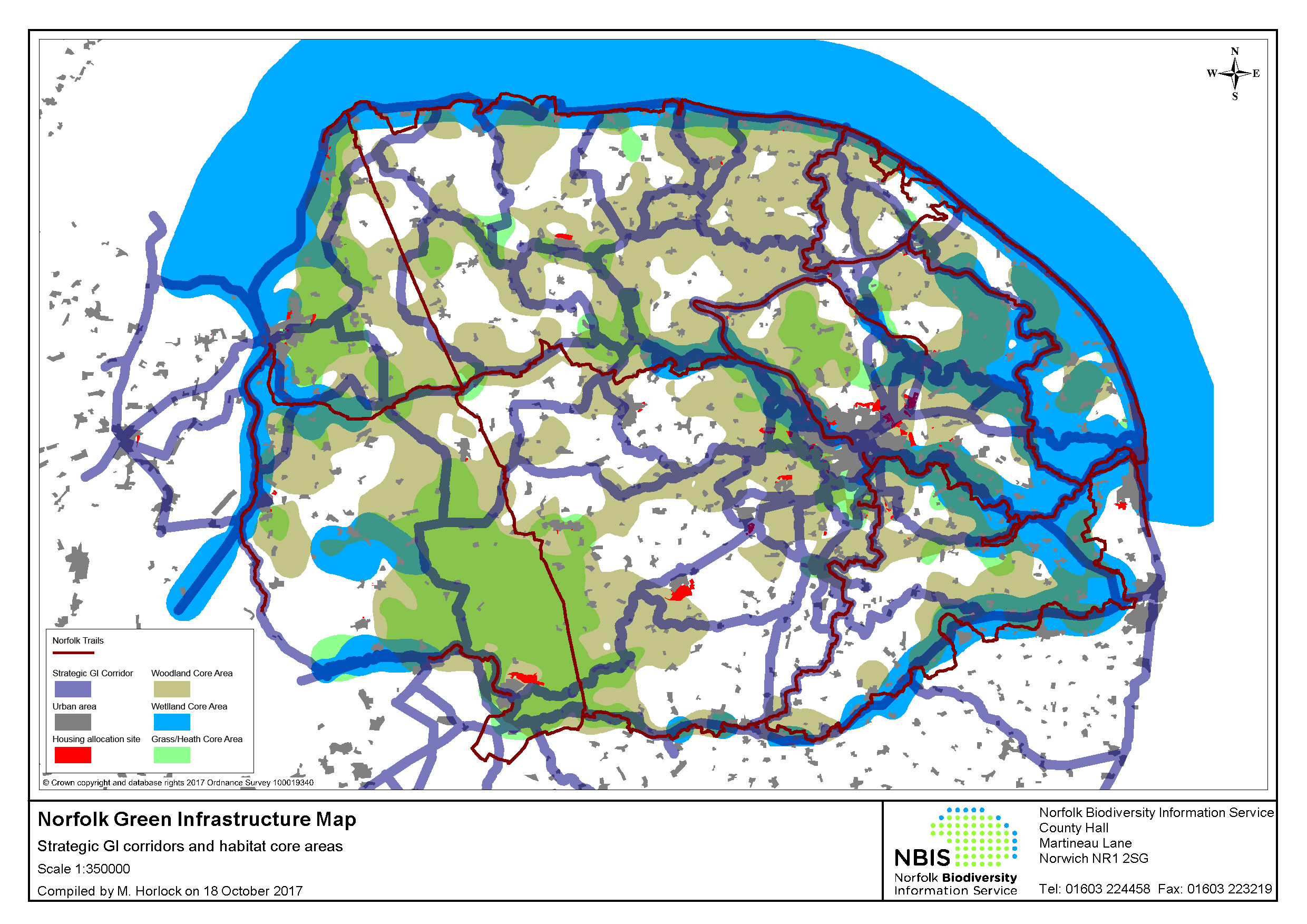
MP7.6 A countywide Green Infrastructure Strategy is under development which will replace the GI strategies developed by the district and borough authorities. The Norfolk Green Infrastructure Map (overleaf) shows strategic GI corridors and habitat core areas. Currently (2018), not all local authority areas within Norfolk are covered by a Green Infrastructure Strategy.
MP7.7 Planning obligations and/or conditions will be used to ensure that progressive restoration and commencement of after-use takes place within an appropriate time-frame during the site's operations or after completion of working phases. Any site restored to 'public amenity' must provide appropriate access to the general public. Planning conditions and/or obligations may be used to determine the required duration of aftercare of restored sites and an agreement for management of such sites in the long term, where appropriate.
MP7.8 Upon cessation of working and restoration of a minerals site, the removal of some local road improvements may be required to meet the provisions outlined in Policy MP7. This will mainly relate to the lower designated, rural routes in the route hierarchy, securing for example the removal of kerbed site accesses and visibility splays, in the interests of landscape and local amenity.
Policy MP7: Progressive working, restoration and after-use
Proposals for new mineral workings must be accompanied by a scheme for the phased and progressive working and restoration of the site throughout its life to ensure that the worked land is reclaimed at the earliest opportunity. Phased and progressive working and restoration must seek to reduce and mitigate potential impacts, including to amenity, landscape, the natural, built and historic environment, through minimising the area of land occupied at any one time by the mineral working.
Applications to vary planning conditions to amend progressive working and restoration schemes will only be acceptable where exceptional circumstances justify a change from the permitted schemes.
Restoration and consequent after-use of mineral extraction sites and associated development will be determined on a case-by-case basis. After-use proposals may include agriculture, forestry, ecology, reservoirs, amenity or flood alleviation.
Preference will be given to restoration that:
- enhances Norfolk's biodiversity (focussing on priority habitats and species in Norfolk),
- contributes positively to identified Green Infrastructure corridors and/or ecological networks, and
- creates high-quality, locally distinctive landscapes.
- Reinstates Best and Most Versatile agricultural land, where it occurs.
The restoration proposal must demonstrate that:
- The appropriate restoration and after-use is both feasible and achievable in the proposed time scales.
- Due consideration has been given to opportunities to improve public access, particularly to implement the County Council's Rights of Way Improvement Plan.
- Due consideration has been given to supporting the aims of the Norfolk Green Infrastructure Strategy / Ecological networks.
- Any important geology or geomorphology on the site will be retained in sample exposures for study purposes where practical and safe to do so.
MP8. Aftercare
MP8.1 Where the proposed restoration of a mineral extraction site is to an agriculture, forestry, amenity or ecology after-use, the outline aftercare strategy sets the general parameters of the proposed action required to bring the restored land up to the required standard for the intended after-use. For an arable agricultural after-use this can entail a particular pattern of cultivation over the five-year aftercare period. Where restoration proposals include the retention of a geological exposure for study, provision should be made in the aftercare strategy for either periodic cleaning of the face of the exposure, or cleaning prior to geological studies taking place.
MP8.2 During the five-year aftercare period annual reports are submitted for the approval of the Mineral Planning Authority following a site meeting to establish if any further action is required, such as the installation of land drainage etc.
MP8.3 Where the proposed after-use is not agriculture, aftercare strategies covering a period greater than five years may be required to ensure the successful establishment and maintenance of the approved after-use. The need for annual reports after the initial five-year period for will be assessed on a case by case basis.
Policy MP8: Aftercare
Where the proposed restoration following mineral extraction is to an agriculture, forestry, amenity or ecology after-use; or includes a geological exposure, an outline aftercare strategy for at least five years is required prior to the determination of the planning application. The outline strategy should set out the land management proposed to bring the restored land up to the required standard for the proposed after-use.
Planning conditions and/or longer-term planning obligations will be used to ensure that a detailed annual management report is provided. The annual management report must include any measures required, following the annual aftercare inspection, to achieve the outline aftercare strategy.
MP9. Concrete batching and asphalt plants
MP9.1 Minerals can only be worked where they occur, which is normally within the open countryside. Ancillary development such as concrete batching plants and asphalt plants would not normally be allowed in the open countryside in the absence of adjacent mineral workings and therefore should be removed once mineral extraction has ceased.
Policy MP9: Concrete batching and asphalt plants
Proposals for concrete batching plants or asphalt plants at sand and gravel workings must stipulate the proportion of indigenous sand and gravel that will be used in the production of ready mixed concrete or asphalt.
At sand and gravel workings, planning permission will be limited to the end date of the quarry permission, or to when the indigenous material no longer forms the majority of the feedstock being used, whichever is the sooner.
Any proposals for concrete batching plants or asphalt plants that are County matters must also comply with the development management criteria set out in Policy MW2.
MP10. Safeguarding of port and rail facilities, and facilities for the manufacture of concrete, asphalt and recycled materials
MP10.1 It is important to safeguard existing, planned or potential infrastructure for the storage, handling, processing and distribution of minerals from incompatible development which may prevent or prejudice the use of these facilities.
MP10.2 The safeguarding of minerals infrastructure is necessary to protect it from other forms of development which might either directly or indirectly impact upon these facilities. Therefore, applications for new development in proximity to existing safeguarded minerals infrastructure should take into account any potential conflicts. Local Planning Authorities are therefore requested to consult the Minerals Planning Authority if a proposed development is within the consultation area of a safeguarded facility.
MP10.3 Decisions on whether a proposed development would prevent or prejudice the continued use of a safeguarded facility and would therefore raise an objection from the Minerals Planning Authority, will be made on a case by case basis. Each decision will take into account the particular use of the safeguarded site, the nature of the proposed development, their compatibility and, where appropriate, any mitigation which could address any adverse impacts. Proposals for non-mineral development within the consultation areas of safeguarded sites would need to provide appropriate mitigation, as an 'agent of change', so as to not prejudice the continued operations of the mineral facility.
MP10.4 The Policies Map will indicate the location of all known safeguarded facilities. Railheads and wharfs handling minerals are listed in Appendix 5.
Policy MP10: safeguarding of port and rail facilities, and facilities for the manufacture of concrete, asphalt and recycled materials
The County Council will safeguard:
- Existing, planned and potential rail heads, rail links to quarries, wharfage and associated storage, handing and processing facilities for the bulk transport by rail, sea or inland waterways of minerals, including recycled, secondary and marine-dredged materials; and
- Existing, planned and potential sites for concrete batching, the manufacture of coated materials, other concrete products and the handling, processing and distribution of substitute, recycled and secondary aggregate material.
Development proposals within 250 metres of the above minerals related facilities should demonstrate that they would not prevent or prejudice the use of those facilities.
The Mineral Planning Authority should be consulted on all development proposals within Minerals Consultation Areas, except for the excluded development types set out in Appendix 4.
The County Council will oppose development proposals which would prevent or prejudice the use of safeguarded sites for those purposes unless suitable alternative provision is made, or the applicant demonstrates that those sites no longer meet the needs of the aggregates industry.
MP11. Minerals Safeguarding Areas and Minerals Consultation Areas
MP11.1 The NPPF states that in preparing local plans, local authorities should: "safeguarding mineral resources by defining Mineral Safeguarding Areas; and adopt appropriate policies so that known locations of specific mineral resources of local and national importance are not sterilised by non-mineral development where this should be avoided (whilst not creating a presumption that resources defined will be worked)". National Planning Practice Guidance states that Mineral Planning Authorities should also define Mineral Consultation Areas.
MP11.2 Minerals are a finite natural resource and can only be worked where they exist. The safeguarding of mineral extraction sites has a number of benefits, both in terms of protecting sources for construction purposes and maintaining a supply of building stone for conservation purposes. Norfolk County Council will therefore safeguard existing, permitted and allocated mineral extraction sites from incompatible development proposals.
MP11.3 The purpose of safeguarding existing and proposed sites is not necessarily to prevent other forms of development from taking place in proximity to those sites, but to ensure that issues of compatibility across the differing forms of development are taken into account in the planning process.
MP11.4 Therefore, applications for new development in proximity to existing safeguarded mineral extraction sites should take into account any potential conflicts. Local Planning Authorities are requested to consult the Mineral Planning Authority if a proposed development is within the consultation area of a safeguarded site. The Minerals Consultation Area will extend 250 metres around each safeguarded mineral extraction site. The safeguarded sites will be identified on the Policies Map and are listed in Appendix 6.
MP11.5 Decisions on whether a proposed development would prevent or prejudice the continued use of a safeguarded site and would therefore raise an objection from the Mineral Planning Authority, will be made on a case by case basis. Each decision would take into account the particular use of the safeguarded site, the nature of the proposed development, their compatibility and, where appropriate, any mitigation which could address any adverse impacts.
MP11.6 Norfolk County Council will also define Minerals Safeguarding Areas (MSAs) and Mineral Consultation Areas (MCAs) to safeguard specific mineral resources. The primary evidence base for defining mineral resources as Mineral Safeguarding Areas is the Norfolk Mineral Resources Map 2004, produced by the British Geological Survey (BGS), as amended by the BGS DiGmapGB-50 dataset. Deposits of aggregates (sand and gravel) are widely distributed across Norfolk and there are very considerable resources. To ensure that the Mineral Safeguarding Areas are proportionate, the area covered by the MSA will include only those deposits which are most likely to be commercially viable. This will normally be those deposits with the highest proportion of gravel.
MP11.7 The table overleaf shows the superficial geology types which have been included within the indicative sand and gravel Minerals Safeguarding Areas. There are two main types of geology; bedrock and superficial. In Norfolk, chalk is the main bedrock material, along with younger crag (sand and gravel) and other sedimentary deposits in some areas. The superficial geology is made up of more recent deposits generally of a sedimentary nature from either ancient river system or as a result of glacial activity, during the Quaternary Period (the most recent geological period).
Superficial geology types
|
BGS superficial geology classifications in Norfolk |
Included in sand and gravel Minerals Safeguarding Area |
|
calcareous tufa |
No |
|
clay and silt |
No |
|
clay, silt and sand |
No |
|
clay, silt, sand and gravel |
No |
|
diamicton |
No |
|
gravel |
Yes |
|
gravel, sand and silt |
Yes |
|
gravel, sand, silt and clay |
Yes |
|
peat |
No |
|
sand |
Yes |
|
sand and gravel |
Yes |
|
sand and silt |
No |
|
sand with clay and gravel |
No |
|
sand, silt and clay |
No |
|
sediment, shell |
No |
|
shelly mudstone |
No |
|
unknown llithology |
No |
MP11.8 In addition to the sand and gravel resource, silica sand and carstone resources will also be safeguarded. Silica sand is scarce both nationally and in Norfolk and it is defined as an important resource in the NPPF, therefore it is appropriate for the entire resource to be safeguarded as part of the MSA. Carstone is also a scare resource in Norfolk and therefore it is appropriate for the entire carstone resource to be safeguarded as part of the MSA. The Minerals Safeguarding Areas will be identified on the Policies Map. The map on page 85 also identifies the Minerals Safeguarding Areas.
MP11.9 Demand for chalk and clay is relatively low in comparison to the extent of the resource in Norfolk and therefore it is not considered necessary to safeguard these deposits. The National Planning Policy Framework states that planning permission must not be granted for peat extraction from new or extended sites and therefore the peat deposit will not be safeguarded as a mineral resource.
MP11.10 For safeguarding mineral resources, the Mineral Planning Authority has determined that the Minerals Consultation Area (MCA) is the same defined area as the Minerals Safeguarding Area (MSA). Local Planning Authorities are required to consult the County Planning Authority on applications for any form of development received within the MCA/MSA, which are likely to affect or be affected by mineral working and meet the criteria outlined in Appendix 4.
MP11.11 The inclusion of land in a MSA/MCA does not necessarily mean that planning permission would be granted for mineral extraction and there may be sound planning reasons why proposals would be rejected. Designation of these areas is intended to ensure that mineral interests are taken into account at the appropriate time. For example, circumstances may arise where it is appropriate to undertaken mineral extraction in advance of development. The NPPF states that planning authorities should "encourage the prior extraction of minerals, where practicable and environmentally feasible, if it is necessary for non-mineral development to take place".
Policy MP11: Minerals Safeguarding Areas and Minerals Consultation Areas
The County Council will safeguard existing, permitted and allocated mineral extraction sites from inappropriate development proposals. Minerals Consultation Areas are delineated on the Policies Map and extend to 250 metres from each safeguarded site. Development proposals within 250 metres of a safeguarded site should demonstrate that they would not prevent or prejudice the use of the safeguarded site for mineral extraction. The County Council will object to development proposals which would prevent or prejudice the use of safeguarded sites for mineral extraction.
The County Council will safeguard Norfolk's silica sand, carstone, and sand and gravel mineral resources, within the Minerals Safeguarding Areas identified on the Policies Map, from inappropriate development proposals. For mineral resources the Minerals Consultation Area is the same defined area as the Mineral Safeguarding Area.
The Mineral Planning Authority should be consulted on all development proposals within Minerals Consultation Areas, except for the excluded development types set out in Appendix 4.
For relevant development proposals located within a Minerals Safeguarding Area the Mineral Planning Authority will expect to see appropriate investigations carried out to assess whether any mineral resource there is of economic value, and if so, whether the mineral could be economically extracted prior to the development taking place.
The conservation benefits of carstone will be a consideration in safeguarding resources.
In line with the NPPF, the Mineral Planning Authority will object to development which would lead to the sterilisation of the mineral resource and it would be for the relevant Local Planning Authority to decide whether there are compelling planning reasons for over-riding this safeguarding objection.
MP12. Energy minerals
MP12.1 Energy minerals include coal, oil and gas. These hydrocarbon resources underpin key aspects of modern society, supplying energy to power industry and heat homes, fuel for transport to carry goods and people all over the world, and raw materials to produce everyday items. The importance of energy security increases the significance of energy supply, and the efficient use of domestic (energy mineral) resources.
MP12.2 Developing domestic supplies of oil and gas is seen as a valuable step in reducing our reliance on imports. Reflecting this, there is an increasing interest from industry and central government in developing onshore supplies that would contribute toward the country's energy security.
MP12.3 Onshore oil and gas supplies can be accessed via the sinking of boreholes, also known as 'wells'. This has taken place in the UK and worldwide for many years.
Background
MP12.4 The National Planning Policy Framework states that when planning for on-shore oil and gas development, including unconventional hydrocarbons, Mineral Planning Authorities should clearly distinguish between, and plan positively for, each of the exploration, appraisal and production phases of hydrocarbon extraction.
MP12.5 Planning permission is one of the main regulatory requirements that operators must meet before drilling a well for both conventional and unconventional hydrocarbons. However, exploration for oil, gas and other hydrocarbons can only take place in areas which have been licensed by the Oil and Gas Authority.
MP12.6 The County Council is responsible for granting permission for the location of any wells and well pads within licensed areas and will impose conditions to ensure that the impact on the land is acceptable. However, it is not the only regulatory body that permission for extraction is required from. Others include:
MP12.7 The Department for Business, Energy and Industrial Strategy (BEIS) - manages the release of Petroleum Exploration and Development Licences (PEDLs) through the Oil and Gas Authority. These licences are put out for tender in rounds; the latest round took place in 2014 (14th round), with the previous round in 2007. As at 2018, although licence blocks in Norfolk were offered in the 14th round, no licences were applied for in Norfolk. Therefore, as at 2018, there are currently no PEDL licence in Norfolk. At the current time a decision on the timing of the next round of PEDL licences administered by BEIS has not been made.
MP12.8 A company that gains a successful exploration licence has exclusive consent to carry out exploration, within the licence block. Exploration may include test drillings once other permissions (including planning permission) and approvals are in place. The Oil and Gas Authority also has responsibility for assessing the risk of, and monitoring seismic activity, as well as granting consent to flaring or venting;
MP12.9 Environment Agency – protects water resources (including groundwater aquifers), ensures appropriate treatment and disposal of mining waste, emissions to air and suitable treatment and management of any naturally occurring radioactive materials;
MP12.10 Health and Safety Executive (HSE) – regulates the safety aspects of all phases of extraction, in particular has responsibility for ensuring the appropriate design and construction of a well casing for any borehole.
Introduction
MP12.11 The BGS has records of exploratory drilling for oil and gas in Norfolk in the 1960's and 1970's. However, all of these exploratory drills are recorded as being dry and abandoned. In the 1980's there was a renewed campaign of seismic testing for oil and gas deposits in Norfolk, but again no potential prospects were identified. While significant oil and gas fields where identified and exploited in the Southern North Sea, the landward extension of the reservoir basin for these deposits occurs in the East Midlands. The East Midlands has been the site of productive oil and gas fields since the beginning of the Second World War. No such equivalent prospective site occurs within Norfolk, as the BGS defines the county of Norfolk as an unprospective area for oil and gas, in that the lack of suitable geology means that a prospect likely to result in commercial quantities of oil and gas does not occur.
MP12.12 Unconventional hydrocarbons are gas obtained from reservoirs made up from rocks other than sandstone and limestone (conventional reservoirs). There are four main unconventional routes to hydrocarbon exploitation:
- Abandoned Mine Methane (AMM), where methane generated in old coal workings is recovered
- Coal Mine Methane (CMM), where methane is captured from active coal workings
- Coal Bed Methane (CBM), where Methane is recovered from coalbeds which have not been subject to mining by drilling into the bed
- Recovering methane by drilling into mudstones and shales; these have traditionally been considered to be too impermeable for commercial production of gas.
MP12.13 Norfolk does not have any onshore coalbeds, although a concealed coal bed occurs slightly offshore. However, this is located at a depth greater than can currently be exploited for CBM, that is, more than 1200m below the surface.
MP12.14 Shale deposits do occur along the western boundary of the county. However, the BGS have assessed that the most likely prospective areas for shale gas recovery in England are within basin settings in the Pennines, northern England, the Midlands, and Wessex and Cleveland basins. Methane recovered from shales is sub-divided into two types dependent on the method of formation. Biogenic methane is generated by the initial breakdown of organic matter at or near the surface. Thermogenic methane is generated as a product of the breakdown of organic material as a result of depth and pressure as the material is progressively buried. Thermally mature basins have the greatest prospect for commercially viable quantities of shale gas. No shale deposits within Norfolk occur within such basins. Biogenic methane has not yet been shown to have occurred in any deposits in the UK, although it has been significant in the rest of the world.
MP12.15 In conclusion, while oil and gas recovery has occurred relatively close to the boundaries of Norfolk, there is no evidence that any prospects underlie the county.
The phases of unconventional hydrocarbon development
MP12.16 In the event that proposals do come forward, Norfolk County Council will require the submission of a new planning application for each key stage of a proposal for oil and gas development. The NPPF outlines three main phases for on-shore oil and gas development, namely: exploration; appraisal; and production.
MP12.17 Based on the information available at the time of writing the Minerals and Waste Local Plan, the Council notes that it is not always possible to distinguish a discrete "appraisal" stage.
MP12.18 Nonetheless, mindful of the need to distinguish different phases where possible (in particular separating the production phase from exploration and/or appraisal) the Council will ensure that unconventional oil and gas development is managed carefully in a phased manner.
MP12.19 For example, if the appraisal of targeted areas post-exploration phase requires additional boreholes to be sunk or horizontally drilled, without entering the production phase, this may require different planning conditions and a further review of the risks involved. In such circumstances it is likely that such appraisal will be considered as a distinct phase of the development and will require separate planning permission.
MP12.20 Effective continuous dialogue
between operators and the Mineral Planning Authority is vital
to ensure each step is carefully considered.
Planning applications for oil and gas development
MP12.21 On receipt of a planning application for oil and gas development, the main planning issues that Norfolk County Council, as Minerals Planning Authority (MPA), must address are broadly similar to other types of mineral development and thus would be considered with reference to the relevant policies in this Plan.
MP12.22 Guidance on the planning application process, including a summary of the key regulators for hydrocarbon extraction and issues that mineral planning authorities can leave to other regulatory regimes is provided in the National Planning Practice Guidance.
MP12.23 Norfolk County Council's policy on oil and gas is presented in MP12, which differentiates between the different stages of development. Exploration and appraisal operations should be for an agreed, temporary length of time. All of the criteria in policy MP12 applicable to the exploration and appraisal stages will also be applicable to production.
MP12.24 The applicant will be required to provide information on how the site has been selected and the extent of the geographical area of search for the oil or gas. The area of search is defined as the area within which the exploration or appraisal will take place in relation to the wider reservoir (the source of the oil or gas). It should be demonstrated that the site selection process has had regard to designations of local, regional and/or national importance. In addition sites of European importance and areas that ecologically support the integrity of these must be considered. It should also be demonstrated that facilities are located to minimise adverse impacts on landscape and visual amenity and offer the best opportunity for the appropriate and adequate mitigation and/or compensation of any adverse impacts.
MP12.25 All proposals for oil and gas development must assess environmental risk to establish the nature and extent of any adverse impacts and identify appropriate mitigation measures. To facilitate this it is important to ensure that all environmental assessments submitted at the planning stage are as complete and up-to-date as possible. For shale gas applications that involve hydraulic fracturing this will include reference to an Environmental Risk Assessment (ERA) completed as best practice under guidance from BEIS.
MP12.26 The application must demonstrate that the proposed location and development is consistent with the 'Onshore Hydraulic Fracturing (Protected Areas) Regulations 2016' (or subsequent regulations) in relation to the Norfolk Coast AONB and the Broads.
MP12.27 The application must demonstrate that drilling at the proposed location will not generate unacceptable adverse impacts on the integrity of the underlying geological structure. As necessary, Norfolk County Council will seek expert advice (for example, from BGS) to verify that all geological data bearing on the application has been considered and that sufficient data are available to make an informed decision. Advice will also be sought from Natural England with regard to ecological data relating to geological features.
MP12.28 In common with all types of mineral development, the Mineral Planning Authority will refer to the Development Plan as a whole when considering any application.
MP12.29 When preparing a proposal for production, as well as covering criteria a-d in as much detail as possible (i.e. revisiting and expanding information submitted during the exploration stages), operators would also be asked to provide information on the outcomes of the appraisal stage (showing that production will be viable), a development framework for the site, and detailed consideration of the economic impacts of the proposal.
MP12.30 All applications will be considered against Environmental Impact Assessment Regulations 2017 (or subsequent regulations). Consideration of cumulative impacts will form an important part of this process.
MP12.31 Appropriate planning obligations and conditions will be sought to ensure that the proposal adheres to the Development Plan.
MP12.32 Community engagement is important for oil and gas development and applicants will be encouraged to engage with both the communities and the Authorities (through pre-application advice). For complex cases, the use of a planning performance agreement will be sought. There is also a 'Community Charter' which the oil and gas industry has committed to for communities that host unconventional oil and gas development.
Policy MP12: Conventional and unconventional oil and gas development
Proposals for the exploration and/or appraisal of oil and gas resources in Norfolk will be permitted subject to the application demonstrating that:
- well sites and associated facilities represent an acceptable environmental option in comparison to other deliverable alternative sites from which the target reservoir can be accessed, taking into account impacts from on-site and off-site activities including HGV movements;
- the proposed development will not generate unacceptable adverse impacts on the environment and local communities;
- drilling at the proposed location will not generate unacceptable adverse impacts on the integrity of the underlying geological structure; and
- measures will be taken to mitigate to acceptable levels adverse impacts on the environment and local communities.
- adheres to criteria a-d above;
- includes a full appraisal programme for the oil and/or gas resource, completed to the satisfaction of the Mineral Planning Authority; and
- includes a development framework for the site, incorporating or supplemented by justification for the number and extent of the proposed production facilities and an assessment of the proposal's economic impacts.