Initial Consultation document
General Policies
7. Presumption in favour of sustainable development
At the heart of the National Planning Policy Framework (NPPF) is a 'presumption in favour of sustainable development' which should be seen as a golden thread running through both plan-making and decision-taking. The wording of the presumption in set out in paragraph 14 of the NPPF.
The NPPF explains the three dimensions of sustainable development (economic, social and environmental) and the roles of the planning system in contributing to the achievement of sustainable development.
An economic role – contributing to building a strong, responsive and competitive economy, by ensuring that sufficient land of the right type is available in the right places and at the right time to support growth and innovation; and by identifying and coordinating development requirements, including the provision of infrastructure;
A social role – supporting strong, vibrant and healthy communities, by providing the supply of housing required to meet the needs of present and future generations; and by creating a high quality built environment, with accessible local services that reflect the community's needs and support its health, social and cultural well-being; and
An environmental role – contributing to protecting and enhancing our natural, built and historic environment; and, as part of this, helping to improve biodiversity, use natural resources prudently, minimise waste and pollution, and mitigate and adapt to climate change including moving to a low carbon economy.
The policies in the Norfolk Minerals and Waste Local Plan will deliver what is considered to be sustainable development in Norfolk.
Paragraph 15 of the National Planning Policy Framework states that Local Plans should be based upon and reflect the presumption in favour of sustainable development with clear policies that will guide how the presumption should be applied locally.
The strategic policy below has been included to clarify the operational relationship between national policy in the NPPF and this Local Plan. The NPPF is a material consideration in the determination of planning applications.
Policy MW1: Presumption in favour of sustainable development
When considering development proposals, the Norfolk County Council will take a positive approach to minerals development and waste management development that reflects the presumption in favour of sustainable development contained in the National Planning Policy Framework. It will always work proactively with applicants and statutory consultees to find solutions which mean that proposals can be approved wherever possible and to secure development that improves the economic, social and environmental considerations of the area.
Planning applications that accord with the policies in this Local Plan will be approved without delay, unless material considerations indicate otherwise.
Where there are no policies relevant to the application or relevant policies are demonstrably out-of-date at the time of making the decision, then the Council will grant planning permission unless material conditions indicate otherwise - taking into account whether:
- Any adverse impacts of granting planning permission would significantly and demonstrably outweigh the benefits, when assessed against the policies in the National Planning Policy Framework taken as whole; or
- Specific policies in the National Planning Policy Framework indicate that development should be restricted.
Question 4: Policy MW1 'Presumption in favour of sustainable development' - Do you agree or disagree with the proposed policy? Do you have any comments or suggestions for alternative policy wording?
8. Development Management Criteria
Minerals and waste developments can result in a range of potential benefits and operational impacts that need to be considered. The planning policy framework provided by this Plan is considered flexible enough to deal with a number of issues that may arise from different development, as well as take into account the local circumstances of each proposal.
National guidance is clear that Local Plans do not need to repeat or reformulate existing national or local policy or duplicate the existing pollution control regime.
The 'Local List for Validation of Planning Applications' adopted by the County Planning Authority provides guidance about the particular information that may be required to validate a planning application before it can be determined. Advice on the information to support an application should be sought on a case-by-case basis, normally through pre-application discussions with the County Planning Authority. For any proposal for minerals or waste management development that comes forward for determination, the impact of the proposal on the environment and amenity, as described below, will be carefully assessed and considered before a decision is made.
Where the impact of the proposal is unacceptable, and such impacts can't be controlled, then planning permission could be refused. Specific measures can, however, be sometimes undertaken to mitigate any potential adverse impact to either local amenity or the environment. Such measures could include, for example, additional landscaping, sustainable drainage schemes, protection of historic assets, noise attenuation, the design of lighting (including avoidance of light pollution of the night sky), dust and vibration control, nature conservation, good building and site design and restrictions on working hours and lorry movements. The appropriate mitigation will depend on the characteristics of the proposal, the site and the surrounding area.
The production of waste is a natural result of economic and social activity by businesses and consumers. Wastes can also be an input to economic activity, either as a material or through energy recovery. The management of that waste has economic implications for productivity, government expenditure, and the environment. The waste industry contributes to the economy of Norfolk as an employer and businesses require effective waste management to offset costs associated with disposing of the waste it produces.
Minerals are essential to support sustainable economic growth and our quality of life. It is therefore important that there is a sufficient supply of material to provide the infrastructure, buildings, energy and goods that the country needs. The minerals industry contributes to the economy of Norfolk as an employer and providing raw materials for the construction of buildings and roads and for glass manufacture.
The provision of minerals and the management of waste are therefore important to the economic growth of Norfolk and this needs to be taken into consideration when assessing planning applications for minerals or waste management development.
The Development Management Criteria Policy MW2 details the issues that will be taken into account when reaching a decision on a particular planning application to ensure that permitted sites represent sustainable development.
Policy MW2: Development Management Criteria
Proposals for minerals development and/or waste management development will be permitted where it can be demonstrated that the development would not have an unacceptable impact (including cumulative impact in combination with other existing or permitted development) on:
- Local amenity and health (including noise levels, odour, air quality, dust, litter, light pollution and vibration);
- The quality of surface waterbodies and groundwater, with particular regard to preventing the deterioration of their existing status, and the quantity of water for resource purposes within water bodies;
- The capacity of existing drainage systems;
- Pluvial and fluvial flood risk;
- The best and most versatile agricultural land;
- Aircraft safety due to the risk of bird strike and/or building height and position;
- The safety and capacity of the road and any other transport network;
- The appearance, quality and character of the landscape, countryside and visual environment and any local features that contribute to its local distinctiveness;
- Public Open Space, the definitive Public Rights of Way network and outdoor recreation facilities;
- Land stability;
- The natural and geological environment (including internationally, nationally or locally designated sites and irreplaceable habitats);
- The historic environment, including heritage and archaeological assets and their settings; and
- The character and quality of the area, in which the development is situated, through poor design.
Where appropriate, enhancement of the environment would be sought, including, but not exclusively, the enhancement of the Public Rights of Way Network, creation of recreation opportunities and enhancement of the natural, historic and built environment and surrounding landscapes.
Question 5: Policy MW2 'Development Management Criteria' - Do you agree or disagree with the proposed policy? Do you have any comments or suggestions for alternative policy wording?
Pollution and Local Amenity Impacts
"Local amenity impact" is usually understood to mean the effect of the proposed development on the existing visual and aural characteristics of the immediate neighbourhood, including the impact on any residential and non-residential uses in the vicinity. Impacts on amenity can cover a range of potential pollution and disturbance from, for example, light, noise, dust, and odour as well as concerns of the possible effects on human health from the development. When considering planning applications the County Planning Authority must be satisfied that those potential adverse impacts have all been satisfactorily investigated and addressed.
The National Planning Policy Framework states that "local planning authorities should focus on whether the development itself is an acceptable use of the land, and the impact of the use, rather than the control of processes or emissions themselves where these are subject to approval under pollution control regimes. LPAs should assume that these regimes will operate effectively."
Detailed controls are exercised through specific pollution prevention and control regimes primarily regulated by the Environment Agency (EA) and Local Authority Environmental Health Officers (EHOs). However, potential pollution and health impacts can be 'material considerations' when determining applications and an assessment of the likely environmental impacts of a proposal could be required. The EA and EHOs will be consulted on minerals and waste planning applications, where appropriate.
Levels of disturbance will vary according to the nature of the proposed development and the relationship to the surrounding area. Factors to be taken into account include:
- The proximity of proposed development to homes, schools and other sensitive and incompatible land-uses,
- The location and siting of plant and other ancillary development,
- The topography of the site and the surrounding area (including natural and man- made features which can reduce impacts, such as landscape features), and,
- The site's relationship with roads, railways and waterways.
Many potential pollution impacts can be overcome by using measures to remove or reduce emissions at source, or by adopting appropriate working practices. Examples of these measures include:
- Controlling working hours,
- Locating plant away from neighbouring developments,
- Housing machinery indoors or attaching silencers to plant,
- Using water sprinklers to reduce dust, installing wheel washing for lorries, and,
- Directing lighting downwards and away from properties.
If permission is granted, planning conditions may be imposed to help mitigate any impact on local amenity.
Biodiversity and Geological Conservation
There are numerous sites of biodiversity and geological interest in Norfolk and these will continue to be afforded strong protection. Norfolk has important international and national designations, namely Special Areas of Conservation, Special Protection Areas, Ramsar Sites, National Nature Reserves and Sites of Special Scientific Interest. There are also important areas of ancient woodland and areas of particular geological significance, some of which are designated as Local Geological Sites.
Within national planning policy, individual sites designated for their importance to biological or geological diversity at an international or national level receive statutory protection, whilst those designated at a local level gain protection through District, Borough or City Local Plans. The Plan seeks to ensure that there are no unacceptable adverse impacts on these important assets. Planning permission for minerals or waste management development affecting an international site (Natura 2000 site) will only be granted where the conclusions of a project-level Habitats Regulations Assessment (HRA), where one is required, demonstrate that the proposal will have no adverse impacts on the integrity of any site, either alone or in combination with other plans or projects.
Minerals or waste management development which impacts on Sites of Special Scientific Interest, National Nature Reserves and irreplaceable priority habitats such as ancient woodland and aged or veteran trees will only be permitted where the impact does not conflict with the wildlife or geological conservation interests of that asset. Locally designated sites form a significant and important part of Norfolk's natural resource, often contributing to ecological connectivity and landscape linkages. Minerals or waste management development that will impact on County Wildlife Sites, Local Geological Sites, Local Nature Reserves, other priority habitats and protected and priority species will only be permitted where it can be demonstrated that the proposal will not significantly harm the site or the benefits of the development outweigh any adverse effects and such effects can be satisfactorily mitigated or, as a last resort, compensated for, e.g. through offsetting. Proposals that can show a positive contribution to the restoration, creation, protection, enhancement and management of ecological networks at the landscape scale will be encouraged.
A baseline ecological survey will be necessary where biodiversity features are present on a proposed site. Such surveys are essential in identifying what exists on a proposed mineral or waste management site and establishing whether such features should be retained and managed.
Visual and Landscape Character Impacts
The character of Norfolk is important to residents and visitors alike. The visual impact experienced as a result of the development of minerals or waste management development on the landscape and townscape is a key consideration when deciding planning applications.
The Norfolk Coast Area of Outstanding Natural Beauty is a nationally important landscape. The north Norfolk coast from Holme-next-the-Sea to Salthouse is also defined as a Heritage Coast which means that it is one of the best stretches of undeveloped coast in England. The Norfolk and Suffolk Broads is Britain's largest protected wetland and has the status of a national park. There are also important areas of ancient woodland across Norfolk, often with veteran trees. Norfolk's river valleys are also distinctive landscape features. All of these landscape features will be strongly protected from any adverse impacts arising from minerals or waste management development.
Landscape Character Assessments have been carried by the Local Planning Authorities in for Norfolk and they consider where locally designated landscapes of importance are situated. Particular features that create local distinctiveness or character should be protected from future loss; this includes features such as topography, habitats that are unique to an area, geology (e.g. unique formations or preserved quarry geology) and historic landscapes (which may contain features such as ancient hedgerows and historic field boundaries). The intrinsic character of the Norfolk countryside should be recognised in preparing proposals for minerals or waste management development.
Mineral development in the countryside should pay particular regard to the local landscape and should aim to protect and enhance this, including through restoration and after-use. Impacts on the landscape can be avoided, reduced or overcome by a variety of measures including:
- Safeguarding local features (such as significant topography, woodland, veteran trees, hedgerows and viewpoints) to retain biodiversity networks and provide part of the framework for restoration,
- Using planting schemes and landscaped bunds and mounds to screen minerals development,
- Early design and planting of appropriate native species to enhance landscape character, support biodiversity networks and provide mature features to be later incorporated into restoration proposals,
- The careful siting of plant and machinery, including providing this at low level and using colour recessive paint.
Recreation
The Public Rights of Way (PROW) network provides an important means of accessing the countryside. Where relevant, applications for minerals or waste management development will be required to ensure that PROW remain usable at all times or provide satisfactory alternative routes. Alternative paths and any necessary diversions of existing paths will be required to be in place prior to the closure of the existing PROW. Restoration schemes should, in the first instance, be seen as an opportunity to enhance and upgrade PROW where possible, especially with regard to the provision of Bridleways as multiuser paths as part of any permission granted. In all cases, restoration schemes should provide for access which is at least as good as that existing before workings began.
The closure of a PROW, where no alternative route is provided, will not normally be acceptable.
Local recreation assets, including Public Open Space and other outdoor facilities such as country parks, are protected in District, Borough and City Local Plans. Open Access Land is designated through the Countryside and Rights of Way (CROW) Act 2000. Minerals and waste management proposals will be expected to mitigate any unacceptable impact on such designations.
Heritage assets
The historic environment contributes towards creating local distinctiveness and a sense of place by understanding our past. Heritage assets (and their setting) are an irreplaceable resource and should be conserved in a manner appropriate to their significance. Within the existing policy hierarchy, individual heritage assets designated at an international or national level receive statutory protection (under specific heritage legislation, such as Scheduled Monuments, Listed Buildings, Conservation Areas, Registered Parks and Gardens, and Registered Battlefields) whilst others designated at a local level are subject to protection through District, Borough and City Local Plans.
Information on archaeological sites and material in Norfolk is held in the Historic Environment Record. However, not all archaeological remains are known about and recorded. To safeguard presently unknown remains, an archaeological assessment should be carried out by the developer if an area is likely to be of high archaeological potential (as implied by the Historic Environment Record). The assessment must be carried out before a planning application is submitted as this will help determine the suitability of the proposal, appropriate methods of working and suitable conditions if planning permission is granted.
Land and soil resources
The presence of the best and most versatile agricultural land (defined as land in grades 1, 2 and 3a of the Agricultural Land Classification) should be taken into account, alongside other sustainability considerations, when minerals development or waste management proposals affect such land. The NPPF states that "where significant development of agricultural land is demonstrated to be necessary, local planning authorities should seek to use areas of poorer quality land in preference to that of a higher quality".
Minerals development is, in almost all cases, a temporary use of land, followed by restoration. Therefore, proposals for mineral working on higher grade agricultural land must protect these soils in order to enable the site to have the potential to revert back to productive agricultural use in the future. Top-soil and sub-soil should be carefully removed and handled with care and stored separately during the preparation and working of a mineral site. This will support later land restoration to agriculture and other beneficial uses. The overall integrity of land and soil should be protected during working and long-term use of the site once it is fully restored.
Measures must be taken to ensure the sides of mineral workings are stable and will not result in subsidence either on or off site. Surrounding areas and properties must not be adversely affected by the effects of subsidence or land slippage. Where mineral sites adjoin roads, railways, bridges, or energy transmission routes, appropriate land margins must be provided to ensure the continued structural integrity of this vital infrastructure.
The transport network
Most current minerals and waste sites in Norfolk are served by Heavy Goods Vehicles (HGVs) using the local road network, although Sibelco's silica sand complex at Leziate exports around three-quarters of the processed silica sand by rail.
The movement of HGVs to and from minerals and waste sites can have significant effects on roads, other road users and the local community. Alternatives to road freight, such as rail and water-borne freight distribution of minerals and waste will be strongly encouraged, but in Norfolk the majority of bulk materials are likely to continue being transported by road as this is currently the most feasible mode of transport.
Much of Norfolk's road network is made up of minor rural roads that are generally unsuitable for large vehicles and heavy traffic flows. A large proportion of Norfolk's unclassified road network is of unsuitable construction and alignment to cater for significant HGV traffic and in additional there can be localised amenity impacts from HGV traffic.
An assessment of the impacts of transporting minerals and associated products to and from quarries, and the movement of waste is a key consideration in determining the acceptability of development proposals. As detailed in Policy MW3 'Transport' it is anticipated that mineral and waste developments proposing reliance on the road network will be accompanied by a Transport Statement or Assessment. If planning permission is granted, it may be necessary to impose restrictions on the number of vehicle movements and the routes used, in order to mitigate against any potential impacts on the highway network and local amenity.
Flooding, water resources and water quality
The risk of flooding should be minimised for people, property and the natural environment. Development can increase surface water run-off to streams and rivers, through increasing built development in the local environment. To prevent or minimise this risk, proposals should incorporate effective surface water management, such as sustainable drainage systems, where necessary to ensure flood risk is not increased.
In general terms, waste treatment (excluding landfill or the management of hazardous waste) is defined as a 'less vulnerable' land-use in the NPPF; therefore, it may be appropriate in Flood Zones 2 and 3a. Sand and gravel extraction and silica sand extraction are defined as 'water compatible development' (potentially appropriate in all flood zones) whilst other mineral working and processing, including carstone extraction, is a 'less vulnerable' land use; therefore minerals development may be appropriate in Flood zones 2 and 3a. A 'sequential test', as set out in the NPPF, is applied to new developments to steer development to areas with the lowest probability of flooding.
As well as flood risk, the effect of minerals and waste management development on all water bodies should be addressed. This includes the quality and quantity of surface water and groundwater. A further consideration could be the protection of sources of drinking water, identified via designated Source Protection Zones. Development proposals must therefore prevent the pollution of surface water and groundwater by chemicals and other contaminants. Minerals development must also ensure there will be no significant change to groundwater or surface water levels, including careful monitoring of any 'dewatering' operations (whereby water is pumped out of a pit to allow dry working below the water table) to ensure no adverse impacts on surrounding water availability.
Potential hazard to aircraft from bird strike
Aerodrome safeguarding guidance is set out in the https://www.gov.uk/government/publications/safeguarding-aerodromes-technical-sites-and-military-explosives-storageareas.
The purpose of safeguarding aerodromes is to ensure that the operation and development of civil and military airfields is not inhibited by development that has the potential to increase the number of birds and the 'birdstrike' risk of aircraft damage or danger to life. The safeguarding area for potential bird hazards is a 13km radius from the centre point of civil and military aerodromes. Other potential risks to aerodromes include buildings and lighting affecting telecommunications and visibility, and tall structures affecting flightpaths.
Waste management facilities, especially non-hazardous landfill sites, have the potential to attract birds. Whilst the process of mineral extraction does not in itself attract bird populations, the restoration and after-use of workings may involve the creation of water features, nature reserves and berry producing plants all of which have the potential to attract flocks of birds.
A number of aerodromes and technical sites are located within Norfolk, or have consultation areas within Norfolk. Within Norfolk safeguarding areas have been established for Norwich Airport and RAF Marham, whilst the safeguarding areas around RAF Mildenhall, RAF Lakenheath and RAF Honington in Suffolk, extend into parts of West Norfolk and Breckland. There are smaller airfields in Norfolk used for business aviation and recreational flying where similar safeguarding considerations also apply. There are also safeguarding areas around the MoD technical sites at Neatishead, Trimingham and Weybourne. The boundary of the safeguarded area for each site is shown on the Policies Map. The location and boundary of a safeguarded site is determined by the consultee and is not a matter of discretion for the County Council.
Proposals for site working, restoration and after-use must give careful consideration to the form of working and landscaping, planting and water features if located within an airport/ aerodrome/ or military safeguarding area.
Cumulative impacts
It is appropriate to consider the cumulative impact of any proposed mineral or waste management development especially upon amenity, the economy, the natural and built environment and the local road network.
In determining an application for new mineral or waste management development, account will normally be taken of the potential cumulative impact with other development within the locality and in particular the area's capacity to absorb that change.
Cumulative impacts from mineral development could arise if mineral sites in proximity to one another were worked at the same time, or if working in a particular area was to continue over a long period of time. Potential applicants should consider what other existing and proposed development will take place under their control, or otherwise, in the area when formulating their own proposals to avoid unacceptable cumulative impacts. The MPA will normally require a primary site to have extraction completed and be undergoing restoration before a new extension area is prepared for extraction.
Where cumulative impacts have not been, or are unable to be satisfactorily addressed through the application, the County Planning Authority could have grounds to refuse permission for that development.
9. Transport
Norfolk's 3rd Local Transport Plan 2011-2026 identifies six priorities: maintaining and managing the highway network, delivering sustainable growth, enhancing strategic connections, reducing emissions, improving road safety and improving accessibility.
Most current minerals and waste sites in Norfolk are served by Heavy Goods Vehicles (HGVs) using the local road network, although Sibelco's silica sand complex at Leziate exports around three-quarters of the processed silica sand by rail.
The movement of HGVs to and from minerals and waste sites can have significant effects on roads, other road users and the local community. Alternatives to road freight, such as rail and water-borne freight distribution of minerals and waste will be strongly encouraged, but in Norfolk the majority of bulk materials are likely to continue being transported by road as this is currently the most feasible mode of transport.
Much of Norfolk's road network is made up of minor rural roads that are generally unsuitable for large vehicles and heavy traffic flows. The impact of HGV traffic on unsuitable roads can be significant in terms of physical damage. A large proportion of Norfolk's unclassified road network is of unsuitable construction and alignment to cater for significant HGV traffic and in additional there can be localised amenity impacts from HGV traffic.
One of the aims of the Highway Authority is to keep commercial vehicles away from areas where their presence would result in danger/unacceptable disruption to the highway or cause irreparable damage.
Highways England is responsible for managing the trunk roads in Norfolk (the A11, A47 and A12). The County Council has, of many years, designated every non-trunk road in Norfolk as a category within the Route Hierarchy. In declining order of appropriateness, the Route Hierarchy is: Principal Roads (generally A roads), Main Distributor Roads (generally B roads), Local Access Roads, HGV access Roads, Tourist Access Roads (generally C roads) and Other Roads (normally C or unclassified roads). The intention for new minerals and waste sites is to ensure that HGVs take the shortest practicable route (avoiding inappropriate junctions and travel through settlements where possible) to the nearest Principal Road or Main Distributor Road.
An assessment of the impacts of transporting minerals and associated products to and from quarries, and the movement of waste is a key consideration in determining the acceptability of development proposals.
Road improvements by, or on behalf of a developer, may be required to mitigate any potential adverse transport impacts. Any improvements must be in accordance with the standard for HGV routes in Norfolk County Council's latest guidance on the Route Hierarchy. In cases where a highways improvement scheme has been identified by the County Highway Authority or Highways England, developers will be required to make an appropriate financial contribution to the scheme.
When determining planning applications for minerals and waste
development, it may be necessary to use planning conditions
to impose restrictions on the number of vehicle movements and
to secure acceptable routing of HGVs when this is considered
necessary to minimise highways and amenity impacts from HGV
transport.
All proposals for minerals development or waste management facilities must assess and consider positively the potential for non-HGV transportation of materials to and from the facilities, principally by rail or water.
The County Council will consider minerals and waste development proposals to be satisfactory in terms of access where anticipated HGV movements, taking into account any mitigation measures proposed, do not generate:
- Unacceptable risks to the safety of road users and pedestrians;
- Unacceptable impacts on the capacity and/or efficiency of the highway network (including the trunk road network);
- Unacceptable impacts on air quality (particularly in relation to any potential breaches of National Air Quality Objectives and impacts on any Air Quality Management Areas);
- Unacceptable physical impacts on the highway network (e.g. road or kerbside damage).
Planning applications for new minerals development or waste management facilities, or proposals that generate an increase in traffic movements or traffic impact, must be accompanied by a Transport Statement or Transport Assessment that demonstrates:
- Suitable highway access and egress in accordance with published highway design guidance;
- A suitable route to the nearest major road (trunk road or principal road or main distributor road), which may need to be incorporated in a formal Routing Agreement;
- Consideration of other road users, including cyclists, horse riders and pedestrians; and
- Measures to reduce car travel to the site by workers and visitors and encourage walking, cycling and use of public transport.
Question 6: Policy MW3 'Transport' - Do you agree or disagree with the proposed policy? Do you have any comments or suggestions for alternative policy wording?
10. Climate change mitigation and adaption
There is a need to reduce the contribution to climate change from minerals development and waste management facilities, while also adapting to its potential effects.
Norfolk is one of the driest counties in the UK and there is a need to minimise demands on potable water resources, particularly in the context of climate change. Large parts of Norfolk are at risk from flooding, particularly coastal and river localities, and particularly from surface water run-off after storm events; again an issue that will be compounded by climate change. The design and siting of new development can contribute to mitigation and adaption to climate change. New minerals development and waste management facilities should therefore include appropriate measures to ensure mitigation and adaption to climate change.
Minerals and waste developments have the potential to generate renewable energy (e.g. through solar panels, wind turbines, ground source heat pumps etc.) which could meet some of their electricity needs. Applicants should endeavour to generate 10 per cent of the energy used on site from decentralised and renewable or low carbon sources. Given the rural location of mineral sites, it is not considered practicable to seek a higher minimum threshold than this. It is recognised that in some cases it may not be practicable to meet the 10 per cent minimum, perhaps because of financial reasons, site size, physiographical constraints of a site, environmental or landscape impacts. If the applicant considers that this is the case, the policy requires evidence to be provided to the County Planning Authority.
Policy MW4 provides the framework for the County Council's determination of minerals and waste development proposals in relation to climate change issues:
Policy MW4: Climate change mitigation and adaption
New minerals sites and waste management facilities (including extensions to existing sites) should, through their construction and operation, minimise their potential contribution to climate change through reducing carbon and methane emissions, incorporate energy and water efficient design strategies and be adaptable to future climatic conditions.
Proposals for new minerals and waste developments (including extensions to existing sites) should:
- take account of landform, layout, building orientation, massing and landscaping to minimise energy consumption, including maximising cooling and avoiding solar gain in the summer,
- be planned so as to minimise carbon dioxide and methane emissions;
- endeavour to generate a minimum of 10 per cent of the energy used on site from decentralised and renewable or low-carbon sources. Where it is not considered practicable to meet this 10 per cent minimum, evidence must be provided to the County Planning Authority;
- demonstrate the use of sustainable drainage systems, water harvesting from impermeable surfaces and layouts that accommodate waste water recycling;
- take account of potential changes in climate including rising sea levels and coastal erosion;
- not result in an unacceptable risk of flooding on site or an increase in flood risk elsewhere, as demonstrated by a Flood Risk Assessment, where required by the National Planning Policy Framework, and;
- incorporate proposals for sustainable travel, including travel plans where appropriate.
Question 7: Policy MW4 'climate change mitigation and adaption' - Do you agree or disagree with the proposed policy? Do you have any comments or suggestions for alternative policy wording?
11. The Brecks Protected Habitats and Species
Covering 39,141ha of heathland, forest and arable farmland, The Brecks is of International and European value to birdlife. Designated in 2006 as a Special Protection Area (SPA) under the European Council's Directive on the Conservation of Wild Birds, The Brecks habitat is important for a range of ground-nesting birds, including the Stone Curlew, Woodlark and Nightjar. The East of England supports 65% of the UK's breeding pairs of Stone Curlew where most breeding is located within The Brecks. The rich biodiversity of The Brecks is also recognised through other statutory conservation designations including four Special Areas of Conservation (SACs), numerous SSSI and National Nature Reserves (NNR). SSSIs and NNRs make up 40% of the total area.
Evidence used to support the adoption of the Breckland Core Strategy in 2009 included research to inform the Habitats Regulations Assessment (HRA) of the Breckland Core Strategy which examined the effects of housing and roads on the distribution of the Stone Curlew in The Brecks. The adopted mitigation policy required that any new built development which may impact on the SPA must be subject to Appropriate Assessment. New built development is not permitted within 1,500m of the edge of the SPA unless it can be demonstrated by an appropriate assessment that the development would not adversely affect the integrity of the SPA. Such circumstances may include the use of existing buildings and development where completely masked from the SPA by existing development.
Stone Curlews are also found outside the SPA; these birds are clearly part of the SPA population and functionally linked. Accordingly, areas have been identified where there are concentrations of Stone Curlew (using data gathered over the periods 1995-2006, and 2007-2015).
In 2013 a "Further Assessments of the Relationship between Buildings and Stone Curlew Distribution" study was carried out by Footprint Ecology on behalf of Breckland Council to update previous work on the effect of buildings and roads on Stone Curlews in The Brecks. Including new analysis and using additional survey data, this study report focused on the effects of buildings on the distribution of breeding Stone Curlew in The Brecks. The report provides strong support for the continuation of a 1,500m zone around the areas capable of supporting Stone Curlews. Within this zone additional built development is likely to have a significant effect on the SPA.
The 2013 research also suggests that the planting of woodland/screening as a mitigation measure is unlikely to be effective and that the effect of nest density is strongest as a result of the amount of buildings rather than type. One of the key aims of the research was to differentiate the effects of nest density due to different building classes. Due to the sample size and number of buildings identified there needs to be an element of caution applied to the results, however, the research indicates that there was no evidence of a negative impact of agricultural or commercial buildings. As such, the analysis suggests that project level HRA for non-residential development in the SPA buffer zones may be able to demonstrate that adverse effects can be ruled out.
Policy MW5: The Brecks Protected Habitats and Species
The Council will require suitable information to be provided to enable it to undertake a Habitats Regulations Assessment of all proposals for development that are likely to have a significant effect on the Breckland Special Protection Area (SPA), which is classified for its populations of Stone Curlew, Woodlark and Nightjar, and/or Breckland Special Area of Conservation (SAC) which is designated for its heathland habitats. Development will only be permitted where it can be demonstrated that the proposal will not adversely affect the integrity of the SPA or SAC.
Stone Curlew
A buffer zone has been defined (indicated in red hatching on Map 2) that extends 1,500m from the edge of those parts of the SPA that support or are capable of supporting Stone Curlew, where new built development would be likely to significantly affect the SPA population.
A buffer zone has also been defined (indicated in orange hatching on Map 2) that extends 1,500 metres around areas that have a functional link to the SPA, because they support Stone Curlew outside, but in close proximity to the SPA boundary, within which new built development would be likely to significantly affect the SPA population.
Built development within the SPA boundary, or located less than 1,500m away from the SPA boundary or identified areas that have a functional link (see Map 2) will not normally be permitted.
Where a proposed building is outside the SPA but within 1,500m of the SPA boundary or identified areas that have a functional link (see Map 2), there may be circumstances where a project level Habitats Regulations Assessment is able to demonstrate that the proposal will not adversely affect the integrity of the SPA.
Circumstances where the proposal is able to conclusively demonstrate that it will not result in an adverse effect on Breckland SPA may include where the proposal is:
- More than 1,500m away from potential stone curlew nesting sites inside the SPA (these are those parts of the SPA that are also designated as Breckland Farmland SSSI);
- A new building that will be completely masked from the SPA by existing built development;
- A proposed re-development of an existing building that would not alter its footprint or increase its potential impact.
Woodlark and Nightjar
Built development within 400m of the SPA that support, or are capable of supporting Woodlark and/or Nightjar will not normally be permitted.
The Council will consider the need for a Habitats Regulations Assessment to determine the implications of development on Nightjar and Woodlark on a case by case basis, depending on the location and nature of the proposal.
Question 8: Policy MW5 'The Brecks Protected Habitats and Species' - Do you agree or disagree with the proposed policy? Do you have any comments or suggestions for alternative policy wording?
12. Agricultural soils
Norfolk is predominately rural in nature and agriculture plays a significant role in the local economy and heritage. Continuing to preserve good quality agricultural land is important as it will benefit the economy as well as Norfolk's landscape.
Grade 1 – excellent quality
Grade 2 – very good quality
Grade 3 – good to moderate quality
Sub-grade 3a – good quality
Sub-grade 3b – moderate quality
Grade 4 – poor quality
Grade 5 – very poor quality
The Best and Most Versatile (BMV) Agricultural Land consists of grades 1, 2 and 3a. The NPPF states that "where significant development of agricultural land is demonstrated to be necessary, local planning authorities should seek to use areas of poorer quality land in preference to that of a higher quality". However, minerals development is, in almost all cases, a temporary use of land, followed by restoration. It is therefore normally possible to remove and store topsoils and subsoils during an operational phase, and then to replace them afterwards to bring a site back into agricultural use, if appropriate.
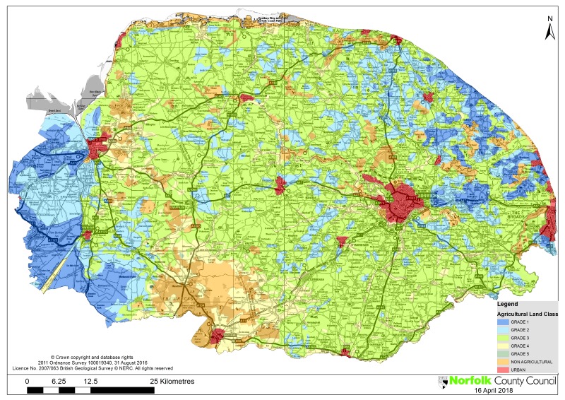
Grade 1 soils are a vital national resource and Norfolk contains some significant areas of Grade 1 land, particularly in the peaty soils of the Fenland area and the Broads. Grade 2 soils are distributed more widely across the county, albeit in smaller patches, but Grade 3 soils make up the majority of Norfolk's agricultural land, with smaller areas of Grade 4 land, located mainly in the drier and more free-draining Brecks.
Given their nature, most waste management facilities will tend to be suitably located on previously developed land and industrial locations and it is not expected that there will be a great need to locate such uses on agricultural land. However, some waste developments, particularly composting, may be more appropriate on agricultural land as opposed to in industrial areas. Where a waste management facility is proposed on BMV agricultural land, policy MW6 will still apply.
Overview Map of Agricultural Land Class
Policy MW6: Agricultural soils
Where development is proposed on agricultural land, the County Council has a clear preference for locating new mineral extraction and associated activities, and composting facilities, on land of agricultural grades 3b, 4 and 5.
Development proposals affecting Grade 1 agricultural land will only be permitted in exceptional circumstances, where it is demonstrated that there are no alternative locations for the development.
In addition to the above, when minerals development, particularly extraction, is proposed on agricultural land of grades 1, 2 or 3a it will only be permitted where:
- Provision is made for high standards of soil management that would enable restoration to a condition at least as good as its previous agricultural quality. To demonstrate this, soil and land quality surveys, and soil handling and replacement strategies (based upon Defra's 'Good Practice Guide for Handling Soils') must be submitted to the County Planning Authority; or
- The benefit of restoring the land to another after-use can be shown to outweigh the loss of the agricultural use of the land.